Waegwan geodata
Waegwan (Gyeongsangbuk-do) is a seat of a third-order administrative division; located in South Korea in Asia/Seoul (GMT+9) time zone. With population of 29,691 people, there are 105 cities with bigger population in this country. Compared to other cities in South Korea, 50.7% of cities are located further ↓South; 83.2% of cities are located further ←West and 58.4% of cities have higher elevation than Waegwan. Note1


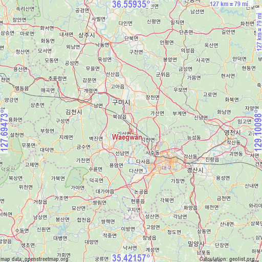
Waegwan GPS coordinates[2]
35° 59' 33.036" North, 128° 23' 52.26" East
| Map corner | latitude | longitude |
|---|---|---|
| Upper-left | 36.55935°, | 127.69473° |
| Center: | 35.99251°, | 128.39785° |
| Lower-right: | 35.42157°, | 129.10098° |
| Map W x H: | 126.5×126.5 km | = 78.6×78.6mi |
| max Lat: | 38.37881° ⇑49.3% North |
| Waegwan: | 35.99251° |
| min Lat: | ⇓50.7% South 33.25333° |
| min Long | Waegwan | max Long |
| 126.10863° | 128.39785° | 129.55377° |
| W 83.2%⇐ | ⇒16.8% E |
Elevation
Elevation of Waegwan is 33 m = 108 ft, and this is 37.4 m = 123 ft below average elevation for this country.
| Max E: |
691 m = 2267 ft | 58.4% |
| Avg. | 70.4 m = 231 ft | |
| Waegwan | 33 m = 108 ft | |
Min E: |
1 m = 3 ft | 41.6% |
See also: South Korea elevation on elevation.city.
Geographical zone
Waegwan is located in North temperate zone (between Tropic of Cancer and the Arctic Circle). Distance of this Northern Tropic circle is 1396.1 km =867.5 mi to South.| Distance of | km | miles | from Waegwan |
|---|---|---|---|
| North Pole | 6005.1 | 3731.4 | to North |
| Arctic Circle | 3399.2 | 2112.2 | to North |
| Tropic Cancer | 1396.1 | 867.5 | to South |
| Equator | 4002 | 2486.7 | to South |


Nearby cities:
15 places around Waegwan: (largest is in red/bold)
• Changnyeong
50.9 km =31.6 mi,  170°
170°
• Chupungnyeong
44.2 km =27.5 mi,  304°
304°
• Daegu
22.1 km =13.7 mi,  127°
127°
• Daehap
42.6 km =26.5 mi, 171°
• Eisen
48 km =29.8 mi,  93°
93°
• Gimcheon
28.8 km =17.9 mi, 299°
• Gumi
14.6 km =9.1 mi,  337°
337°
• Gyeongsan-si
35.9 km =22.3 mi,  121°
121°
• Hayang
39 km =24.2 mi,  103°
103°
• Hwanggan
51.4 km =31.9 mi, 301°
• Hwawŏn
23.2 km =14.4 mi,  156°
156°
• Hyeonpung
33.3 km =20.7 mi, 172°
• Jenzan
29 km =18 mi, 341°
• Kunwi
31.2 km =19.4 mi,  30°
30°
• Sangju
51.6 km =32.1 mi, 335°
Sources, notices
• [Note1] Compared only with cities in South Korea existing in our database
• [Src1] Map data: © OpenStreetMap contributors (CC-BY-SA)
• [Src2] Other city data from geonames.org with taken over terms of usage.
• [Src3] Geographical zone / Annual Mean Temperature by Robert A. Rohde @ Wikipedia
