Iksan geodata
Iksan (Jeollabuk-do) is a populated place; located in South Korea in Asia/Seoul (GMT+9) time zone. With population of 283,501 people, there are 27 cities with bigger population in this country. Compared to other cities in South Korea, 51% of cities are located further ↑North; 69.2% of cities are located further →East and 80.8% of cities have higher elevation than Iksan. Note1


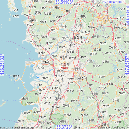
Iksan GPS coordinates[2]
35° 56' 38.004" North, 126° 57' 15.984" East
| Map corner | latitude | longitude |
|---|---|---|
| Upper-left | 36.51108°, | 126.25132° |
| Center: | 35.94389°, | 126.95444° |
| Lower-right: | 35.3726°, | 127.65757° |
| Map W x H: | 126.6×126.6 km | = 78.7×78.7mi |
| max Lat: | 38.37881° ⇑51% North |
| Iksan: | 35.94389° |
| min Lat: | ⇓49% South 33.25333° |
| min Long | Iksan | max Long |
| 126.10863° | 126.95444° | 129.55377° |
| W 30.8%⇐ | ⇒69.2% E |
Elevation
Elevation of Iksan is 16 m = 52 ft, and this is 54.4 m = 178 ft below average elevation for this country.
| Max E: |
691 m = 2267 ft | 80.8% |
| Avg. | 70.4 m = 231 ft | |
| Iksan | 16 m = 52 ft | |
Min E: |
1 m = 3 ft | 19.2% |
See also: Iksan elevation on elevation.city.
Geographical zone
Iksan is located in North temperate zone (between Tropic of Cancer and the Arctic Circle). Distance of this Northern Tropic circle is 1390.7 km =864.1 mi to South.| Distance of | km | miles | from Iksan |
|---|---|---|---|
| North Pole | 6010.5 | 3734.8 | to North |
| Arctic Circle | 3404.6 | 2115.5 | to North |
| Tropic Cancer | 1390.7 | 864.1 | to South |
| Equator | 3996.6 | 2483.4 | to South |


Nearby cities:
15 places around Iksan: (largest is in red/bold)
• Biin
38.4 km =23.9 mi,  304°
304°
• Buyeo
37 km =23 mi,  353°
353°
• Chilbo
38 km =23.6 mi,  174°
174°
• Gunsan
22.2 km =13.8 mi,  280°
280°
• Gwanchon
41.3 km =25.7 mi,  136°
136°
• Gyuam
37.4 km =23.2 mi, 350°
• Jeongeup
38.4 km =23.9 mi,  185°
185°
• Jeonju
22.2 km =13.8 mi,  127°
127°
• Kimje
16.9 km =10.5 mi,  200°
200°
• Nonsan
31.2 km =19.4 mi,  22°
22°
• Puan
31.3 km =19.4 mi,  219°
219°
• Sangwol
42.5 km =26.4 mi, 23°
• Sannae
42.4 km =26.3 mi, 170°
• Wanju
20.6 km =12.8 mi,  122°
122°
• Yŏnmu
24.4 km =15.2 mi,  32°
32°
Sources, notices
• [Note1] Compared only with cities in South Korea existing in our database
• [Src1] Map data: © OpenStreetMap contributors (CC-BY-SA)
• [Src2] Other city data from geonames.org with taken over terms of usage.
• [Src3] Geographical zone / Annual Mean Temperature by Robert A. Rohde @ Wikipedia
