Chinju geodata
Chinju (Gyeongsangnam-do) is a populated place; located in South Korea in Asia/Seoul (GMT+9) time zone. With population of 307,242 people, there are 24 cities with bigger population in this country. Compared to other cities in South Korea, 73.8% of cities are located further ↑North; 79.4% of cities are located further ←West and 58.4% of cities have higher elevation than Chinju. Note1


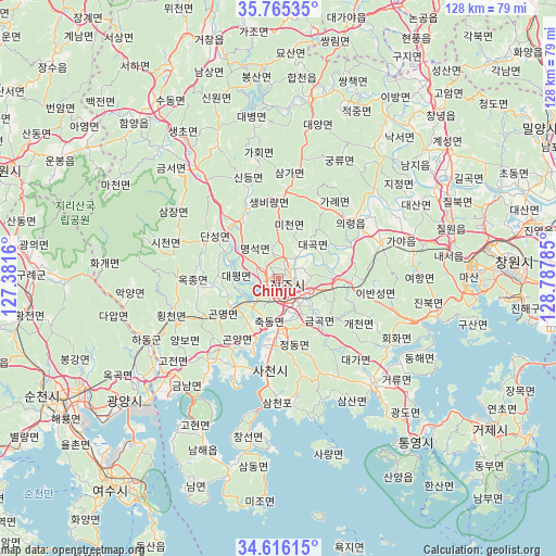
Chinju GPS coordinates[2]
35° 11' 34.008" North, 128° 5' 4.992" East
| Map corner | latitude | longitude |
|---|---|---|
| Upper-left | 35.76535°, | 127.3816° |
| Center: | 35.19278°, | 128.08472° |
| Lower-right: | 34.61615°, | 128.78785° |
| Map W x H: | 127.8×127.8 km | = 79.4×79.4mi |
| max Lat: | 38.37881° ⇑73.8% North |
| Chinju: | 35.19278° |
| min Lat: | ⇓26.2% South 33.25333° |
| min Long | Chinju | max Long |
| 126.10863° | 128.08472° | 129.55377° |
| W 79.4%⇐ | ⇒20.6% E |
Elevation
Elevation of Chinju is 33 m = 108 ft, and this is 37.4 m = 123 ft below average elevation for this country.
| Max E: |
691 m = 2267 ft | 58.4% |
| Avg. | 70.4 m = 231 ft | |
| Chinju | 33 m = 108 ft | |
Min E: |
1 m = 3 ft | 41.6% |
See also: Chinju elevation on elevation.city.
Geographical zone
Chinju is located in North temperate zone (between Tropic of Cancer and the Arctic Circle). Distance of this Northern Tropic circle is 1307.2 km =812.3 mi to South.| Distance of | km | miles | from Chinju |
|---|---|---|---|
| North Pole | 6094 | 3786.6 | to North |
| Arctic Circle | 3488.1 | 2167.4 | to North |
| Tropic Cancer | 1307.2 | 812.3 | to South |
| Equator | 3913.1 | 2431.5 | to South |


Nearby cities:
15 places around Chinju: (largest is in red/bold)
• Bonggang
50 km =31.1 mi,  246°
246°
• Byeonggok
52.4 km =32.6 mi,  315°
315°
• Geumseong
36.9 km =22.9 mi,  226°
226°
• Goseong
32.4 km =20.1 mi,  137°
137°
• Gwangyang
45.1 km =28 mi, 231°
• Hadong
33.3 km =20.7 mi, 245°
• Jeongnyang
30.5 km =19 mi, 246°
• Jinsang
38.3 km =23.8 mi,  240°
240°
• Jinwol
38 km =23.6 mi, 231°
• Kwangyang
51.2 km =31.8 mi, 241°
• Naesŏ
40 km =24.9 mi,  80°
80°
• Nammyeon
50.1 km =31.1 mi,  201°
201°
• Okgok
41.7 km =25.9 mi, 237°
• Ongnyong
46.6 km =29 mi, 245°
• Sangju
52.9 km =32.9 mi,  189°
189°
Sources, notices
• [Note1] Compared only with cities in South Korea existing in our database
• [Src1] Map data: © OpenStreetMap contributors (CC-BY-SA)
• [Src2] Other city data from geonames.org with taken over terms of usage.
• [Src3] Geographical zone / Annual Mean Temperature by Robert A. Rohde @ Wikipedia
