Gaigeturi geodata
Gaigeturi (Jeju-do) is a populated place; located in South Korea in Asia/Seoul (GMT+9) time zone. With population of 23,717 people, there are 117 cities with bigger population in this country. Compared to other cities in South Korea, 99.7% of cities are located further ↑North; 96.9% of cities are located further →East and 93.4% of cities have higher elevation than Gaigeturi. Note1


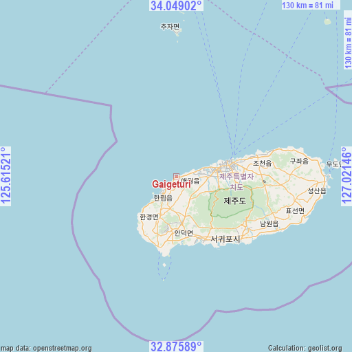
Gaigeturi GPS coordinates[2]
33° 27' 51.984" North, 126° 19' 5.988" East
| Map corner | latitude | longitude |
|---|---|---|
| Upper-left | 34.04902°, | 125.61521° |
| Center: | 33.46444°, | 126.31833° |
| Lower-right: | 32.87589°, | 127.02146° |
| Map W x H: | 130.4×130.4 km | = 81×81mi |
| max Lat: | 38.37881° ⇑99.7% North |
| Gaigeturi: | 33.46444° |
| min Lat: | ⇓0.3% South 33.25333° |
| min Long | Gaigeturi | max Long |
| 126.10863° | 126.31833° | 129.55377° |
| W 3.1%⇐ | ⇒96.9% E |
Elevation
Elevation of Gaigeturi is 8 m = 26 ft, and this is 62.4 m = 205 ft below average elevation for this country.
| Max E: |
691 m = 2267 ft | 93.4% |
| Avg. | 70.4 m = 231 ft | |
| Gaigeturi | 8 m = 26 ft | |
Min E: |
1 m = 3 ft | 6.6% |
See also: South Korea elevation on elevation.city.
Geographical zone
Gaigeturi is located in North temperate zone (between Tropic of Cancer and the Arctic Circle). Distance of this Northern Tropic circle is 1115 km =692.8 mi to South.| Distance of | km | miles | from Gaigeturi |
|---|---|---|---|
| North Pole | 6286.2 | 3906.1 | to North |
| Arctic Circle | 3680.3 | 2286.8 | to North |
| Tropic Cancer | 1115 | 692.8 | to South |
| Equator | 3720.9 | 2312.1 | to South |


Nearby cities:
15 places around Gaigeturi: (largest is in red/bold)
• Apae
155.9 km =96.9 mi,  359°
359°
• Deokjin
154.6 km =96.1 mi,  13°
13°
• Dopo
156.5 km =97.2 mi, 11°
• Haenam
125.7 km =78.1 mi, 11°
• Illo
155.1 km =96.4 mi, 5°
• Jangheung
145.8 km =90.6 mi,  21°
21°
• Jeju City
19.5 km =12.1 mi,  75°
75°
• Mokpo
150.1 km =93.3 mi,  2°
2°
• Palgeum
147.8 km =91.8 mi,  353°
353°
• Seogwipo
32.6 km =20.3 mi,  136°
136°
• Sijong
158.4 km =98.4 mi, 9°
• Sinan
152.3 km =94.6 mi, 1°
• Sinan
152.6 km =94.8 mi, 352°
• Yeongam
152.6 km =94.8 mi, 13°
• Yuchi
156.3 km =97.1 mi, 17°
Sources, notices
• [Note1] Compared only with cities in South Korea existing in our database
• [Src1] Map data: © OpenStreetMap contributors (CC-BY-SA)
• [Src2] Other city data from geonames.org with taken over terms of usage.
• [Src3] Geographical zone / Annual Mean Temperature by Robert A. Rohde @ Wikipedia
