Seogwipo geodata
Seogwipo (Jeju-do) is a populated place; located in South Korea in Asia/Seoul (GMT+9) time zone. With population of 155,691 people, there are 39 cities with bigger population in this country. Compared to other cities in South Korea, 100% of cities are located further ↑North; 87.1% of cities are located further →East and 66.1% of cities have lower elevation than Seogwipo. Note1


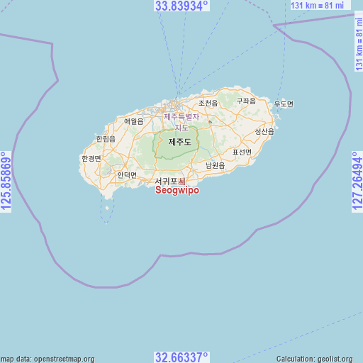
Seogwipo GPS coordinates[2]
33° 15' 11.988" North, 126° 33' 42.516" East
| Map corner | latitude | longitude |
|---|---|---|
| Upper-left | 33.83934°, | 125.85869° |
| Center: | 33.25333°, | 126.56181° |
| Lower-right: | 32.66337°, | 127.26494° |
| Map W x H: | 130.8×130.8 km | = 81.3×81.3mi |
| max Lat: | 38.37881° ⇑100% North |
| Seogwipo: | 33.25333° |
| min Lat: | ⇓0% South 33.25333° |
| min Long | Seogwipo | max Long |
| 126.10863° | 126.56181° | 129.55377° |
| W 12.9%⇐ | ⇒87.1% E |
Elevation
Elevation of Seogwipo is 69 m = 226 ft, and this is 1.4 m = 5 ft below average elevation for this country.
| Max E: |
691 m = 2267 ft | 33.9% |
| Avg. | 70.4 m = 231 ft | |
| Seogwipo | 69 m = 226 ft | |
Min E: |
1 m = 3 ft | 66.1% |
See also: Seogwipo elevation on elevation.city.
Geographical zone
Seogwipo is located in North temperate zone (between Tropic of Cancer and the Arctic Circle). Distance of this Northern Tropic circle is 1091.5 km =678.2 mi to South.| Distance of | km | miles | from Seogwipo |
|---|---|---|---|
| North Pole | 6309.6 | 3920.6 | to North |
| Arctic Circle | 3703.8 | 2301.4 | to North |
| Tropic Cancer | 1091.5 | 678.2 | to South |
| Equator | 3697.4 | 2297.5 | to South |


Nearby cities:
15 places around Seogwipo: (largest is in red/bold)
• Boseong
175.4 km =109 mi,  15°
15°
• Deokjin
174.6 km =108.5 mi,  4°
4°
• Dopo
177.2 km =110.1 mi, 2°
• Gaigeturi
32.6 km =20.3 mi,  316°
316°
• Haenam
146.6 km =91.1 mi, 1°
• Illo
177.9 km =110.5 mi,  357°
357°
• Jangheung
162 km =100.7 mi,  11°
11°
• Jeju City
28.7 km =17.8 mi,  352°
352°
• Miryeok
178.8 km =111.1 mi, 15°
• Mokpo
174.1 km =108.2 mi, 354°
• Nodong
178 km =110.6 mi, 15°
• Palgeum
174.7 km =108.6 mi, 347°
• Sinan
176.8 km =109.9 mi, 353°
• Yeongam
172.5 km =107.2 mi, 4°
• Yuchi
174.1 km =108.2 mi, 8°
Sources, notices
• [Note1] Compared only with cities in South Korea existing in our database
• [Src1] Map data: © OpenStreetMap contributors (CC-BY-SA)
• [Src2] Other city data from geonames.org with taken over terms of usage.
• [Src3] Geographical zone / Annual Mean Temperature by Robert A. Rohde @ Wikipedia
