Az Zawr geodata
Az Zawr (Al Asimah) is a populated place; located in Kuwait in Asia/Kuwait (GMT+3) time zone. With population of 5,750 people, there are 20 cities with bigger population in this country. Compared to other cities in Kuwait, 100% of cities are located further ↓South; 100% of cities are located further ←West and 96% of cities have higher elevation than Az Zawr. Note1


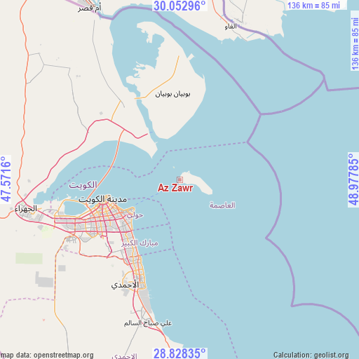
Az Zawr GPS coordinates[2]
29° 26' 33" North, 48° 16' 28.992" East
| Map corner | latitude | longitude |
|---|---|---|
| Upper-left | 30.05296°, | 47.5716° |
| Center: | 29.4425°, | 48.27472° |
| Lower-right: | 28.82835°, | 48.97785° |
| Map W x H: | 136.2×136.2 km | = 84.6×84.6mi |
| max Lat: | 29.4425° ⇑0% North |
| Az Zawr: | 29.4425° |
| min Lat: | ⇓100% South 28.63917° |
| min Long | Az Zawr | max Long |
| 47.65806° | 48.27472° | 48.27472° |
| W 100%⇐ | ⇒0% E |
Elevation
Elevation of Az Zawr is 5 m = 16 ft, and this is 21.7 m = 71 ft below average elevation for this country.
| Max E: |
164 m = 538 ft | 96% |
| Avg. | 26.7 m = 88 ft | |
| Az Zawr | 5 m = 16 ft | |
Min E: |
4 m = 13 ft | 4% |
See also: Kuwait elevation on elevation.city.
Geographical zone
Az Zawr is located in North temperate zone (between Tropic of Cancer and the Arctic Circle). Distance of this Northern Tropic circle is 667.8 km =415 mi to South.| Distance of | km | miles | from Az Zawr |
|---|---|---|---|
| North Pole | 6733.4 | 4183.9 | to North |
| Arctic Circle | 4127.5 | 2564.7 | to North |
| Tropic Cancer | 667.8 | 415 | to South |
| Equator | 3273.7 | 2034.2 | to South |


Nearby cities:
15 places around Az Zawr: (largest is in red/bold)
• Abu Al Hasaniya
32.1 km =19.9 mi,  209°
209°
• Abu Fatira
31.9 km =19.8 mi, 211°
• Ad Dasmah
27.8 km =17.3 mi,  251°
251°
• Al Finţās
33.4 km =20.8 mi, 206°
• Al Funayţīs
29.4 km =18.3 mi, 214°
• Al-Masayel
28.9 km =18 mi,  218°
218°
• Ar Rumaythīyah
24.3 km =15.1 mi,  233°
233°
• As Sālimīyah
22.7 km =14.1 mi,  237°
237°
• Ash Shāmīyah
32.1 km =19.9 mi, 250°
• Bayān
26.8 km =16.7 mi, 234°
• Kuwait City
29.8 km =18.5 mi, 254°
• Mubārak al Kabīr
33.5 km =20.8 mi, 212°
• Salwá
25 km =15.5 mi, 229°
• Şabāḩ as Sālim
29.5 km =18.3 mi, 225°
• Ḩawallī
26.8 km =16.7 mi, 242°
Sources, notices
• [Note1] Compared only with cities in Kuwait existing in our database
• [Src1] Map data: © OpenStreetMap contributors (CC-BY-SA)
• [Src2] Other city data from geonames.org with taken over terms of usage.
• [Src3] Geographical zone / Annual Mean Temperature by Robert A. Rohde @ Wikipedia
