Garliava geodata
Garliava (Kaunas) is a populated place; located in Lithuania in Europe/Vilnius (GMT+3) time zone. With population of 13,809 people, there are 37 cities with bigger population in this country. Compared to other cities in Lithuania, 67.9% of cities are located further ↑North; 53.7% of cities are located further →East and 61.9% of cities have higher elevation than Garliava. Note1


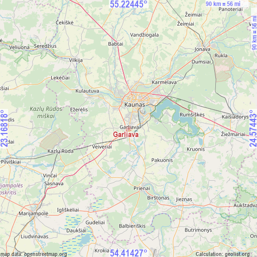
Garliava GPS coordinates[2]
54° 49' 17.004" North, 23° 52' 16.68" East
| Map corner | latitude | longitude |
|---|---|---|
| Upper-left | 55.22445°, | 23.16818° |
| Center: | 54.82139°, | 23.8713° |
| Lower-right: | 54.41427°, | 24.57443° |
| Map W x H: | 90.1×90.1 km | = 56×56mi |
| max Lat: | 56.36149° ⇑67.9% North |
| Garliava: | 54.82139° |
| min Lat: | ⇓32.1% South 54.01573° |
| min Long | Garliava | max Long |
| 20.99651° | 23.8713° | 26.43984° |
| W 46.3%⇐ | ⇒53.7% E |
Elevation
Elevation of Garliava is 72 m = 236 ft, and this is 18.7 m = 61 ft below average elevation for this country.
| Max E: |
204 m = 669 ft | 61.9% |
| Avg. | 90.7 m = 298 ft | |
| Garliava | 72 m = 236 ft | |
Min E: |
-1 m = -3 ft | 38.1% |
See also: Lithuania elevation on elevation.city.
Geographical zone
Garliava is located in North temperate zone (between Tropic of Cancer and the Arctic Circle). Distance of this North polar circle is 1305.6 km =811.3 mi to North.| Distance of | km | miles | from Garliava |
|---|---|---|---|
| North Pole | 3911.5 | 2430.5 | to North |
| Arctic Circle | 1305.6 | 811.3 | to North |
| Tropic Cancer | 3489.6 | 2168.3 | to South |
| Equator | 6095.6 | 3787.6 | to South |


Nearby cities:
15 places around Garliava: (largest is in red/bold)
• Akademija (Kaunas)
8.9 km =5.5 mi,  340°
340°
• Aleksotas
7 km =4.3 mi,  19°
19°
• Dainava (Kaunas)
12.1 km =7.5 mi,  30°
30°
• Eiguliai
12.8 km =8 mi, 17°
• Ežerėlis
18.4 km =11.4 mi,  291°
291°
• Karmėlava
20.6 km =12.8 mi,  36°
36°
• Kaunas
9.4 km =5.8 mi, 15°
• Kačerginė
15.9 km =9.9 mi,  321°
321°
• Kulautuva
19.9 km =12.4 mi,  312°
312°
• Linksmakalnis
8 km =5 mi,  152°
152°
• Mastaiciai
1.7 km =1.1 mi,  264°
264°
• Noreikiškės
7.5 km =4.7 mi,  348°
348°
• Ramučiai
17.4 km =10.8 mi, 35°
• Sargėnai
14.2 km =8.8 mi,  3°
3°
• Šilainiai
12 km =7.5 mi, 4°
Sources, notices
• [Note1] Compared only with cities in Lithuania existing in our database
• [Src1] Map data: © OpenStreetMap contributors (CC-BY-SA)
• [Src2] Other city data from geonames.org with taken over terms of usage.
• [Src3] Geographical zone / Annual Mean Temperature by Robert A. Rohde @ Wikipedia
