Linksmakalnis geodata
Linksmakalnis (Kaunas) is a populated place; located in Lithuania in Europe/Vilnius (GMT+3) time zone. With population of 817 people, there are 127 cities with bigger population in this country. Compared to other cities in Lithuania, 72.4% of cities are located further ↑North; 50.7% of cities are located further ←West and 70.1% of cities have higher elevation than Linksmakalnis. Note1


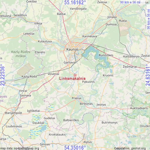
Linksmakalnis GPS coordinates[2]
54° 45' 28.512" North, 23° 55' 42.528" East
| Map corner | latitude | longitude |
|---|---|---|
| Upper-left | 55.16162°, | 23.22536° |
| Center: | 54.75792°, | 23.92848° |
| Lower-right: | 54.35016°, | 24.63161° |
| Map W x H: | 90.2×90.2 km | = 56×56mi |
| max Lat: | 56.36149° ⇑72.4% North |
| Linksmakalnis: | 54.75792° |
| min Lat: | ⇓27.6% South 54.01573° |
| min Long | Linksmakalnis | max Long |
| 20.99651° | 23.92848° | 26.43984° |
| W 50.7%⇐ | ⇒49.3% E |
Elevation
Elevation of Linksmakalnis is 66 m = 217 ft, and this is 24.7 m = 81 ft below average elevation for this country.
| Max E: |
204 m = 669 ft | 70.1% |
| Avg. | 90.7 m = 298 ft | |
| Linksmakalnis | 66 m = 217 ft | |
Min E: |
-1 m = -3 ft | 29.9% |
See also: Lithuania elevation on elevation.city.
Geographical zone
Linksmakalnis is located in North temperate zone (between Tropic of Cancer and the Arctic Circle). Distance of this North polar circle is 1312.7 km =815.7 mi to North.| Distance of | km | miles | from Linksmakalnis |
|---|---|---|---|
| North Pole | 3918.6 | 2434.9 | to North |
| Arctic Circle | 1312.7 | 815.7 | to North |
| Tropic Cancer | 3482.6 | 2164 | to South |
| Equator | 6088.5 | 3783.2 | to South |


Nearby cities:
15 places around Linksmakalnis: (largest is in red/bold)
• Akademija (Kaunas)
16.8 km =10.4 mi,  336°
336°
• Aleksotas
13.7 km =8.5 mi,  354°
354°
• Birštonas
18 km =11.2 mi,  157°
157°
• Dainava (Kaunas)
17.7 km =11 mi,  8°
8°
• Eiguliai
19.3 km =12 mi,  0°
0°
• Garliava
8 km =5 mi,  332°
332°
• Jieznas
23.7 km =14.7 mi,  137°
137°
• Kaunas
16.1 km =10 mi,  355°
355°
• Kačerginė
23.8 km =14.8 mi, 325°
• Mastaiciai
8.7 km =5.4 mi,  322°
322°
• Noreikiškės
15.3 km =9.5 mi, 340°
• Prienai
13.6 km =8.5 mi,  175°
175°
• Ramučiai
22.2 km =13.8 mi,  17°
17°
• Sargėnai
21.5 km =13.4 mi, 352°
• Šilainiai
19.2 km =11.9 mi, 351°
Sources, notices
• [Note1] Compared only with cities in Lithuania existing in our database
• [Src1] Map data: © OpenStreetMap contributors (CC-BY-SA)
• [Src2] Other city data from geonames.org with taken over terms of usage.
• [Src3] Geographical zone / Annual Mean Temperature by Robert A. Rohde @ Wikipedia
