Širvintos geodata
Širvintos (Vilnius) is a seat of a second-order administrative division; located in Lithuania in Europe/Vilnius (GMT+3) time zone. With population of 7,321 people, there are 56 cities with bigger population in this country. Compared to other cities in Lithuania, 54.5% of cities are located further ↑North; 73.9% of cities are located further ←West and 68.7% of cities have lower elevation than Širvintos. Note1


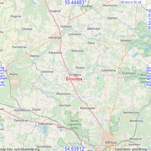
Širvintos GPS coordinates[2]
55° 2' 38.4" North, 24° 57' 16.056" East
| Map corner | latitude | longitude |
|---|---|---|
| Upper-left | 55.44483°, | 24.25134° |
| Center: | 55.044°, | 24.95446° |
| Lower-right: | 54.63912°, | 25.65759° |
| Map W x H: | 89.6×89.6 km | = 55.7×55.7mi |
| max Lat: | 56.36149° ⇑54.5% North |
| Širvintos: | 55.044° |
| min Lat: | ⇓45.5% South 54.01573° |
| min Long | Širvintos | max Long |
| 20.99651° | 24.95446° | 26.43984° |
| W 73.9%⇐ | ⇒26.1% E |
Elevation
Elevation of Širvintos is 115 m = 377 ft, and this is 24.3 m = 80 ft above average elevation for this country.
| Max E: |
204 m = 669 ft | 31.3% |
| Širvintos | 115 m 377 ft | |
| Avg. | 90.7 m = 298 ft | |
Min E: |
-1 m = -3 ft | 68.7% |
See also: Lithuania elevation on elevation.city.
Geographical zone
Širvintos is located in North temperate zone (between Tropic of Cancer and the Arctic Circle). Distance of this North polar circle is 1280.9 km =795.9 mi to North.| Distance of | km | miles | from Širvintos |
|---|---|---|---|
| North Pole | 3886.7 | 2415.1 | to North |
| Arctic Circle | 1280.9 | 795.9 | to North |
| Tropic Cancer | 3514.4 | 2183.7 | to South |
| Equator | 6120.3 | 3803 | to South |


Nearby cities:
15 places around Širvintos: (largest is in red/bold)
• Elektrėnai
34.3 km =21.3 mi,  212°
212°
• Fabijoniškės
39.1 km =24.3 mi,  151°
151°
• Grigiškės
40.9 km =25.4 mi,  168°
168°
• Jonava
43 km =26.7 mi,  275°
275°
• Justiniškės
40.1 km =24.9 mi,  155°
155°
• Kaišiadorys
36.9 km =22.9 mi,  237°
237°
• Molėtai
35.6 km =22.1 mi,  55°
55°
• Nemenčinė
39.5 km =24.5 mi,  123°
123°
• Pašilaičiai
38.4 km =23.9 mi, 153°
• Pilaitė
41 km =25.5 mi, 159°
• Ukmerge
26.3 km =16.3 mi,  330°
330°
• Vepriai
27 km =16.8 mi,  296°
296°
• Vievis
32.4 km =20.1 mi,  197°
197°
• Šeškinė
41.7 km =25.9 mi, 152°
• Žiežmariai
42.1 km =26.2 mi,  231°
231°
Sources, notices
• [Note1] Compared only with cities in Lithuania existing in our database
• [Src1] Map data: © OpenStreetMap contributors (CC-BY-SA)
• [Src2] Other city data from geonames.org with taken over terms of usage.
• [Src3] Geographical zone / Annual Mean Temperature by Robert A. Rohde @ Wikipedia
