Molėtai geodata
Molėtai (Utena) is a seat of a second-order administrative division; located in Lithuania in Europe/Vilnius (GMT+3) time zone. With population of 7,243 people, there are 58 cities with bigger population in this country. Compared to other cities in Lithuania, 53% of cities are located further ↓South; 90.3% of cities are located further ←West and 92.5% of cities have lower elevation than Molėtai. Note1


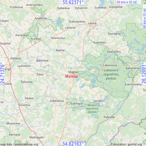
Molėtai GPS coordinates[2]
55° 13' 28.884" North, 25° 25' 0.768" East
| Map corner | latitude | longitude |
|---|---|---|
| Upper-left | 55.62371°, | 24.71376° |
| Center: | 55.22469°, | 25.41688° |
| Lower-right: | 54.82163°, | 26.12001° |
| Map W x H: | 89.2×89.2 km | = 55.4×55.4mi |
| max Lat: | 56.36149° ⇑47% North |
| Molėtai: | 55.22469° |
| min Lat: | ⇓53% South 54.01573° |
| min Long | Molėtai | max Long |
| 20.99651° | 25.41688° | 26.43984° |
| W 90.3%⇐ | ⇒9.7% E |
Elevation
Elevation of Molėtai is 164 m = 538 ft, and this is 73.3 m = 240 ft above average elevation for this country.
| Max E: |
204 m = 669 ft | 7.5% |
| Molėtai | 164 m 538 ft | |
| Avg. | 90.7 m = 298 ft | |
Min E: |
-1 m = -3 ft | 92.5% |
See also: Lithuania elevation on elevation.city.
Geographical zone
Molėtai is located in North temperate zone (between Tropic of Cancer and the Arctic Circle). Distance of this North polar circle is 1260.8 km =783.4 mi to North.| Distance of | km | miles | from Molėtai |
|---|---|---|---|
| North Pole | 3866.7 | 2402.7 | to North |
| Arctic Circle | 1260.8 | 783.4 | to North |
| Tropic Cancer | 3534.5 | 2196.2 | to South |
| Equator | 6140.4 | 3815.5 | to South |


Nearby cities:
15 places around Molėtai: (largest is in red/bold)
• Anyksciai
38.9 km =24.2 mi,  329°
329°
• Fabijoniškės
55.8 km =34.7 mi,  191°
191°
• Ignalina
48.8 km =30.3 mi,  74°
74°
• Justiniškės
57.9 km =36 mi, 192°
• Kavarskas
38.7 km =24 mi,  306°
306°
• Nemenčinė
42 km =26.1 mi,  175°
175°
• Pabradė
34.8 km =21.6 mi,  141°
141°
• Pašilaičiai
56 km =34.8 mi, 193°
• Ukmerge
42.4 km =26.3 mi,  273°
273°
• Utena
32.5 km =20.2 mi,  20°
20°
• Vepriai
54.1 km =33.6 mi,  261°
261°
• Šeškinė
58.2 km =36.2 mi, 190°
• Širvintos
35.6 km =22.1 mi,  235°
235°
• Švenčionys
48.2 km =30 mi,  101°
101°
• Švenčionėliai
37.8 km =23.5 mi, 100°
Sources, notices
• [Note1] Compared only with cities in Lithuania existing in our database
• [Src1] Map data: © OpenStreetMap contributors (CC-BY-SA)
• [Src2] Other city data from geonames.org with taken over terms of usage.
• [Src3] Geographical zone / Annual Mean Temperature by Robert A. Rohde @ Wikipedia
