Ragaciems geodata
Ragaciems (Engure) is a populated place; located in Latvia in Europe/Riga (GMT+3) time zone. With population of 670 people, there are 107 cities with bigger population in this country. Compared to other cities in Latvia, 62.1% of cities are located further ↓South; 75% of cities are located further →East and 99.3% of cities have higher elevation than Ragaciems. Note1


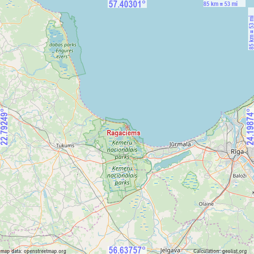
Ragaciems GPS coordinates[2]
57° 1' 20.136" North, 23° 29' 44.196" East
| Map corner | latitude | longitude |
|---|---|---|
| Upper-left | 57.40301°, | 22.79249° |
| Center: | 57.02226°, | 23.49561° |
| Lower-right: | 56.63757°, | 24.19874° |
| Map W x H: | 85.1×85.1 km | = 52.9×52.9mi |
| max Lat: | 57.89752° ⇑37.9% North |
| Ragaciems: | 57.02226° |
| min Lat: | ⇓62.1% South 55.75284° |
| min Long | Ragaciems | max Long |
| 21.01085° | 23.49561° | 28.12165° |
| W 25%⇐ | ⇒75% E |
Elevation
Elevation of Ragaciems is 3 m = 10 ft, and this is 62.4 m = 205 ft below average elevation for this country.
| Max E: |
212 m = 696 ft | 99.3% |
| Avg. | 65.4 m = 215 ft | |
| Ragaciems | 3 m = 10 ft | |
Min E: |
2 m = 7 ft | 0.7% |
See also: Latvia elevation on elevation.city.
Geographical zone
Ragaciems is located in North temperate zone (between Tropic of Cancer and the Arctic Circle). Distance of this North polar circle is 1060.9 km =659.2 mi to North.| Distance of | km | miles | from Ragaciems |
|---|---|---|---|
| North Pole | 3666.8 | 2278.4 | to North |
| Arctic Circle | 1060.9 | 659.2 | to North |
| Tropic Cancer | 3734.4 | 2320.4 | to South |
| Equator | 6340.3 | 3939.7 | to South |


Nearby cities:
15 places around Ragaciems: (largest is in red/bold)
• Bolderaja
33.9 km =21.1 mi,  88°
88°
• Daugavgrīva
32.8 km =20.4 mi, 85°
• Engure
22.4 km =13.9 mi,  313°
313°
• Jūrmala
17.7 km =11 mi,  109°
109°
• Kalngale
40.6 km =25.2 mi,  81°
81°
• Mežaparks
40.3 km =25 mi, 93°
• Milzkalne
17.1 km =10.6 mi,  253°
253°
• Mārupe
36.1 km =22.4 mi, 111°
• Olaine
36.8 km =22.9 mi,  133°
133°
• Ozolnieki
40.7 km =25.3 mi,  155°
155°
• Piņķi
26.9 km =16.7 mi, 109°
• Riga
37.9 km =23.5 mi,  102°
102°
• Smārde
12.2 km =7.6 mi,  231°
231°
• Tukums
21.5 km =13.4 mi, 253°
• Tīreļi
21.1 km =13.1 mi, 164°
Sources, notices
• [Note1] Compared only with cities in Latvia existing in our database
• [Src1] Map data: © OpenStreetMap contributors (CC-BY-SA)
• [Src2] Other city data from geonames.org with taken over terms of usage.
• [Src3] Geographical zone / Annual Mean Temperature by Robert A. Rohde @ Wikipedia
