Jaunjelgava geodata
Jaunjelgava is a seat of a first-order administrative division; located in Latvia in Europe/Riga (GMT+3) time zone. With population of 1,938 people, there are 76 cities with bigger population in this country. Compared to other cities in Latvia, 70.7% of cities are located further ↑North; 60% of cities are located further ←West and 62.1% of cities have higher elevation than Jaunjelgava. Note1


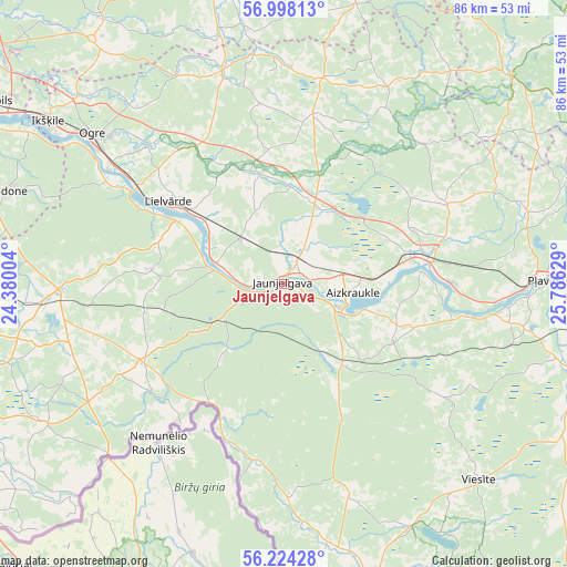
Jaunjelgava GPS coordinates[2]
56° 36' 47.484" North, 25° 4' 59.376" East
| Map corner | latitude | longitude |
|---|---|---|
| Upper-left | 56.99813°, | 24.38004° |
| Center: | 56.61319°, | 25.08316° |
| Lower-right: | 56.22428°, | 25.78629° |
| Map W x H: | 86×86 km | = 53.4×53.4mi |
| max Lat: | 57.89752° ⇑70.7% North |
| Jaunjelgava: | 56.61319° |
| min Lat: | ⇓29.3% South 55.75284° |
| min Long | Jaunjelgava | max Long |
| 21.01085° | 25.08316° | 28.12165° |
| W 60%⇐ | ⇒40% E |
Elevation
Elevation of Jaunjelgava is 44 m = 144 ft, and this is 21.4 m = 70 ft below average elevation for this country.
| Max E: |
212 m = 696 ft | 62.1% |
| Avg. | 65.4 m = 215 ft | |
| Jaunjelgava | 44 m = 144 ft | |
Min E: |
2 m = 7 ft | 37.9% |
See also: Latvia elevation on elevation.city.
Geographical zone
Jaunjelgava is located in North temperate zone (between Tropic of Cancer and the Arctic Circle). Distance of this North polar circle is 1106.4 km =687.5 mi to North.| Distance of | km | miles | from Jaunjelgava |
|---|---|---|---|
| North Pole | 3712.3 | 2306.7 | to North |
| Arctic Circle | 1106.4 | 687.5 | to North |
| Tropic Cancer | 3688.9 | 2292.2 | to South |
| Equator | 6294.8 | 3911.4 | to South |


Nearby cities:
15 places around Jaunjelgava: (largest is in red/bold)
• Aizkraukle
10.6 km =6.6 mi,  95°
95°
• Baldone
44.2 km =27.5 mi,  289°
289°
• Ikšķile
43.4 km =27 mi,  304°
304°
• Jumprava
9.8 km =6.1 mi,  315°
315°
• Koknese
22 km =13.7 mi,  78°
78°
• Lielvārde
20.7 km =12.9 mi,  305°
305°
• Mālpils
44.8 km =27.8 mi,  350°
350°
• Ogre
36.5 km =22.7 mi, 308°
• Pļaviņas
39.3 km =24.4 mi,  89°
89°
• Sala
43.4 km =27 mi,  105°
105°
• Skrīveri
4.2 km =2.6 mi,  32°
32°
• Vecumnieki
34.3 km =21.3 mi,  268°
268°
• Viesīte
41.4 km =25.7 mi,  135°
135°
• Ērgļi
46.2 km =28.7 mi,  46°
46°
• Ķegums
26.4 km =16.4 mi, 303°
Sources, notices
• [Note1] Compared only with cities in Latvia existing in our database
• [Src1] Map data: © OpenStreetMap contributors (CC-BY-SA)
• [Src2] Other city data from geonames.org with taken over terms of usage.
• [Src3] Geographical zone / Annual Mean Temperature by Robert A. Rohde @ Wikipedia
