Ikšķile geodata
Ikšķile is a seat of a first-order administrative division; located in Latvia in Europe/Riga (GMT+3) time zone. With population of 3,368 people, there are 50 cities with bigger population in this country. Compared to other cities in Latvia, 56.4% of cities are located further ↑North; 53.6% of cities are located further →East and 66.4% of cities have higher elevation than Ikšķile. Note1


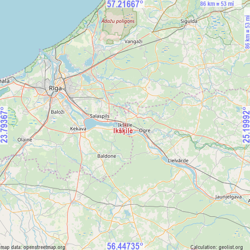
Ikšķile GPS coordinates[2]
56° 50' 2.364" North, 24° 29' 48.444" East
| Map corner | latitude | longitude |
|---|---|---|
| Upper-left | 57.21667°, | 23.79367° |
| Center: | 56.83399°, | 24.49679° |
| Lower-right: | 56.44735°, | 25.19992° |
| Map W x H: | 85.5×85.5 km | = 53.1×53.1mi |
| max Lat: | 57.89752° ⇑56.4% North |
| Ikšķile: | 56.83399° |
| min Lat: | ⇓43.6% South 55.75284° |
| min Long | Ikšķile | max Long |
| 21.01085° | 24.49679° | 28.12165° |
| W 46.4%⇐ | ⇒53.6% E |
Elevation
Elevation of Ikšķile is 36 m = 118 ft, and this is 29.4 m = 96 ft below average elevation for this country.
| Max E: |
212 m = 696 ft | 66.4% |
| Avg. | 65.4 m = 215 ft | |
| Ikšķile | 36 m = 118 ft | |
Min E: |
2 m = 7 ft | 33.6% |
See also: Latvia elevation on elevation.city.
Geographical zone
Ikšķile is located in North temperate zone (between Tropic of Cancer and the Arctic Circle). Distance of this North polar circle is 1081.8 km =672.2 mi to North.| Distance of | km | miles | from Ikšķile |
|---|---|---|---|
| North Pole | 3687.7 | 2291.4 | to North |
| Arctic Circle | 1081.8 | 672.2 | to North |
| Tropic Cancer | 3713.4 | 2307.4 | to South |
| Equator | 6319.3 | 3926.6 | to South |


Nearby cities:
15 places around Ikšķile: (largest is in red/bold)
• Baldone
11.5 km =7.1 mi,  210°
210°
• Baloži
23.5 km =14.6 mi,  281°
281°
• Berģi
20.8 km =12.9 mi,  324°
324°
• Garkalne
23.9 km =14.9 mi,  348°
348°
• Lielvārde
22.7 km =14.1 mi,  123°
123°
• Mežaparks
27.5 km =17.1 mi,  312°
312°
• Ogre
7.4 km =4.6 mi,  105°
105°
• Riga
26.8 km =16.7 mi,  297°
297°
• Ropaži
17.7 km =11 mi,  27°
27°
• Salaspils
8.5 km =5.3 mi,  290°
290°
• Ulbroka
16.3 km =10.1 mi, 314°
• Vecumnieki
25.4 km =15.8 mi,  176°
176°
• Ādaži
28 km =17.4 mi,  339°
339°
• Ķegums
17 km =10.6 mi,  125°
125°
• Ķekava
16.3 km =10.1 mi,  267°
267°
Sources, notices
• [Note1] Compared only with cities in Latvia existing in our database
• [Src1] Map data: © OpenStreetMap contributors (CC-BY-SA)
• [Src2] Other city data from geonames.org with taken over terms of usage.
• [Src3] Geographical zone / Annual Mean Temperature by Robert A. Rohde @ Wikipedia
