Aizkraukle geodata
Aizkraukle (Aizkraukles novads) is a seat of a first-order administrative division; located in Latvia in Europe/Riga (GMT+3) time zone. With population of 8,840 people, there are 28 cities with bigger population in this country. Compared to other cities in Latvia, 72.9% of cities are located further ↑North; 62.1% of cities are located further ←West and 67.1% of cities have lower elevation than Aizkraukle. Note1


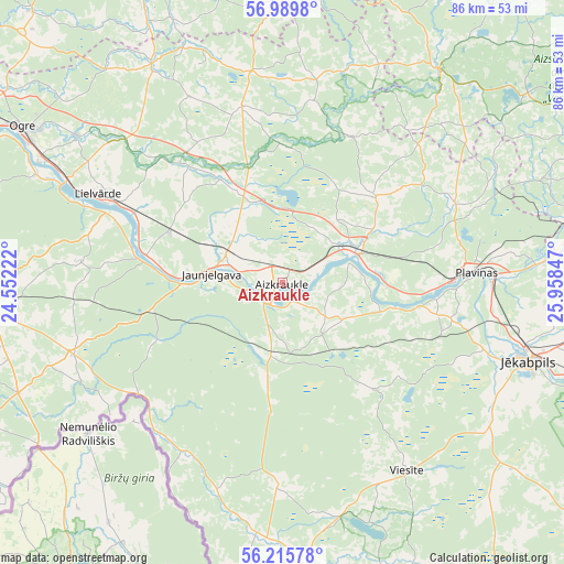
Aizkraukle GPS coordinates[2]
56° 36' 17.172" North, 25° 15' 19.224" East
| Map corner | latitude | longitude |
|---|---|---|
| Upper-left | 56.9898°, | 24.55222° |
| Center: | 56.60477°, | 25.25534° |
| Lower-right: | 56.21578°, | 25.95847° |
| Map W x H: | 86.1×86.1 km | = 53.5×53.5mi |
| max Lat: | 57.89752° ⇑72.9% North |
| Aizkraukle: | 56.60477° |
| min Lat: | ⇓27.1% South 55.75284° |
| min Long | Aizkraukle | max Long |
| 21.01085° | 25.25534° | 28.12165° |
| W 62.1%⇐ | ⇒37.9% E |
Elevation
Elevation of Aizkraukle is 88 m = 289 ft, and this is 22.6 m = 74 ft above average elevation for this country.
| Max E: |
212 m = 696 ft | 32.9% |
| Aizkraukle | 88 m 289 ft | |
| Avg. | 65.4 m = 215 ft | |
Min E: |
2 m = 7 ft | 67.1% |
See also: Latvia elevation on elevation.city.
Geographical zone
Aizkraukle is located in North temperate zone (between Tropic of Cancer and the Arctic Circle). Distance of this North polar circle is 1107.3 km =688 mi to North.| Distance of | km | miles | from Aizkraukle |
|---|---|---|---|
| North Pole | 3713.2 | 2307.3 | to North |
| Arctic Circle | 1107.3 | 688 | to North |
| Tropic Cancer | 3687.9 | 2291.6 | to South |
| Equator | 6293.9 | 3910.8 | to South |


Nearby cities:
15 places around Aizkraukle: (largest is in red/bold)
• Jaunjelgava
10.6 km =6.6 mi,  275°
275°
• Jumprava
19 km =11.8 mi,  294°
294°
• Jēkabpils
38.7 km =24 mi,  107°
107°
• Koknese
12.2 km =7.6 mi,  64°
64°
• Krustpils
38.6 km =24 mi, 105°
• Lielvārde
30.3 km =18.8 mi,  295°
295°
• Nereta
44.8 km =27.8 mi,  175°
175°
• Ogre
45.7 km =28.4 mi, 300°
• Pļaviņas
28.8 km =17.9 mi,  87°
87°
• Sala
33 km =20.5 mi, 109°
• Skrīveri
9.4 km =5.8 mi, 298°
• Vecumnieki
44.9 km =27.9 mi,  270°
270°
• Viesīte
34 km =21.1 mi,  147°
147°
• Ērgļi
40 km =24.9 mi,  35°
35°
• Ķegums
36 km =22.4 mi, 295°
Sources, notices
• [Note1] Compared only with cities in Latvia existing in our database
• [Src1] Map data: © OpenStreetMap contributors (CC-BY-SA)
• [Src2] Other city data from geonames.org with taken over terms of usage.
• [Src3] Geographical zone / Annual Mean Temperature by Robert A. Rohde @ Wikipedia
