Jumprava geodata
Jumprava (Ogre) is a populated place; located in Latvia in Europe/Riga (GMT+3) time zone. With population of 2,177 people, there are 68 cities with bigger population in this country. Compared to other cities in Latvia, 65.7% of cities are located further ↑North; 57.1% of cities are located further ←West and 57.1% of cities have lower elevation than Jumprava. Note1


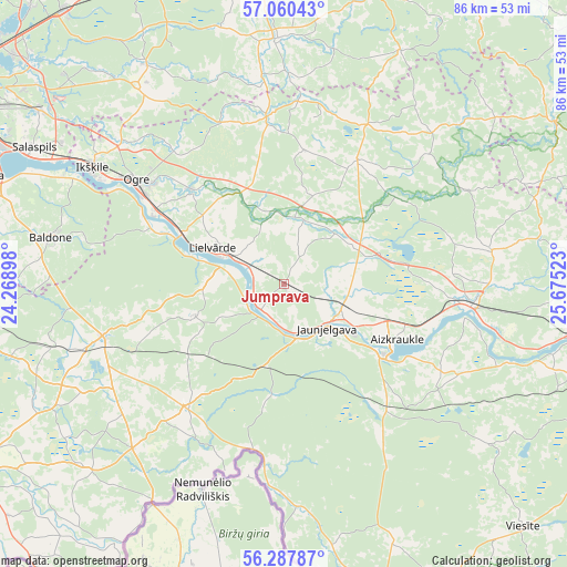
Jumprava GPS coordinates[2]
56° 40' 34.068" North, 24° 58' 19.56" East
| Map corner | latitude | longitude |
|---|---|---|
| Upper-left | 57.06043°, | 24.26898° |
| Center: | 56.67613°, | 24.9721° |
| Lower-right: | 56.28787°, | 25.67523° |
| Map W x H: | 85.9×85.9 km | = 53.4×53.4mi |
| max Lat: | 57.89752° ⇑65.7% North |
| Jumprava: | 56.67613° |
| min Lat: | ⇓34.3% South 55.75284° |
| min Long | Jumprava | max Long |
| 21.01085° | 24.9721° | 28.12165° |
| W 57.1%⇐ | ⇒42.9% E |
Elevation
Elevation of Jumprava is 70 m = 230 ft, and this is 4.6 m = 15 ft above average elevation for this country.
| Max E: |
212 m = 696 ft | 42.9% |
| Jumprava | 70 m 230 ft | |
| Avg. | 65.4 m = 215 ft | |
Min E: |
2 m = 7 ft | 57.1% |
See also: Latvia elevation on elevation.city.
Geographical zone
Jumprava is located in North temperate zone (between Tropic of Cancer and the Arctic Circle). Distance of this North polar circle is 1099.4 km =683.1 mi to North.| Distance of | km | miles | from Jumprava |
|---|---|---|---|
| North Pole | 3705.3 | 2302.4 | to North |
| Arctic Circle | 1099.4 | 683.1 | to North |
| Tropic Cancer | 3695.9 | 2296.5 | to South |
| Equator | 6301.8 | 3915.8 | to South |


Nearby cities:
15 places around Jumprava: (largest is in red/bold)
• Aizkraukle
19 km =11.8 mi,  114°
114°
• Baldone
35.7 km =22.2 mi,  282°
282°
• Ikšķile
33.9 km =21.1 mi,  301°
301°
• Jaunjelgava
9.8 km =6.1 mi,  135°
135°
• Koknese
28.5 km =17.7 mi,  95°
95°
• Lielvārde
11.2 km =7 mi, 296°
• Mālpils
37.1 km =23.1 mi,  358°
358°
• Ogre
26.8 km =16.7 mi,  305°
305°
• Pļaviņas
46.5 km =28.9 mi, 98°
• Ropaži
39.1 km =24.3 mi,  328°
328°
• Salaspils
42.3 km =26.3 mi, 298°
• Skrīveri
9.7 km =6 mi, 110°
• Vecumnieki
28.6 km =17.8 mi,  254°
254°
• Ērgļi
47.4 km =29.5 mi,  58°
58°
• Ķegums
17 km =10.6 mi, 296°
Sources, notices
• [Note1] Compared only with cities in Latvia existing in our database
• [Src1] Map data: © OpenStreetMap contributors (CC-BY-SA)
• [Src2] Other city data from geonames.org with taken over terms of usage.
• [Src3] Geographical zone / Annual Mean Temperature by Robert A. Rohde @ Wikipedia
