Ulbroka geodata
Ulbroka (Stopiņi) is a seat of a first-order administrative division; located in Latvia in Europe/Riga (GMT+3) time zone. With population of 2,800 people, there are 56 cities with bigger population in this country. Compared to other cities in Latvia, 50% of cities are located further ↓South; 59.3% of cities are located further →East and 76.4% of cities have higher elevation than Ulbroka. Note1


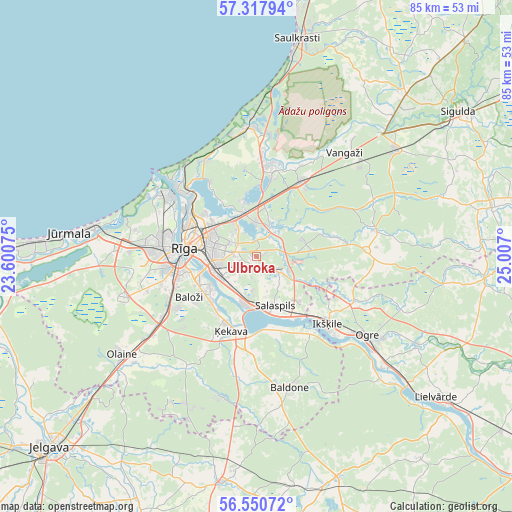
Ulbroka GPS coordinates[2]
56° 56' 10.68" North, 24° 18' 13.932" East
| Map corner | latitude | longitude |
|---|---|---|
| Upper-left | 57.31794°, | 23.60075° |
| Center: | 56.9363°, | 24.30387° |
| Lower-right: | 56.55072°, | 25.007° |
| Map W x H: | 85.3×85.3 km | = 53×53mi |
| max Lat: | 57.89752° ⇑50% North |
| Ulbroka: | 56.9363° |
| min Lat: | ⇓50% South 55.75284° |
| min Long | Ulbroka | max Long |
| 21.01085° | 24.30387° | 28.12165° |
| W 40.7%⇐ | ⇒59.3% E |
Elevation
Elevation of Ulbroka is 21 m = 69 ft, and this is 44.4 m = 146 ft below average elevation for this country.
| Max E: |
212 m = 696 ft | 76.4% |
| Avg. | 65.4 m = 215 ft | |
| Ulbroka | 21 m = 69 ft | |
Min E: |
2 m = 7 ft | 23.6% |
See also: Latvia elevation on elevation.city.
Geographical zone
Ulbroka is located in North temperate zone (between Tropic of Cancer and the Arctic Circle). Distance of this North polar circle is 1070.5 km =665.2 mi to North.| Distance of | km | miles | from Ulbroka |
|---|---|---|---|
| North Pole | 3676.3 | 2284.3 | to North |
| Arctic Circle | 1070.5 | 665.2 | to North |
| Tropic Cancer | 3724.8 | 2314.5 | to South |
| Equator | 6330.7 | 3933.7 | to South |


Nearby cities:
15 places around Ulbroka: (largest is in red/bold)
• Baloži
13.1 km =8.1 mi,  239°
239°
• Berģi
5.6 km =3.5 mi,  357°
357°
• Bolderaja
18.4 km =11.4 mi,  305°
305°
• Daugavgrīva
20.1 km =12.5 mi, 306°
• Garkalne
14 km =8.7 mi,  30°
30°
• Ikšķile
16.3 km =10.1 mi,  134°
134°
• Jaunciems
13.9 km =8.6 mi,  325°
325°
• Kalngale
18.1 km =11.2 mi, 331°
• Mežaparks
11.2 km =7 mi, 309°
• Mārupe
15.7 km =9.8 mi,  257°
257°
• Riga
12.1 km =7.5 mi,  275°
275°
• Ropaži
20.4 km =12.7 mi,  77°
77°
• Salaspils
9.3 km =5.8 mi,  156°
156°
• Ādaži
15.1 km =9.4 mi,  7°
7°
• Ķekava
13 km =8.1 mi,  200°
200°
Sources, notices
• [Note1] Compared only with cities in Latvia existing in our database
• [Src1] Map data: © OpenStreetMap contributors (CC-BY-SA)
• [Src2] Other city data from geonames.org with taken over terms of usage.
• [Src3] Geographical zone / Annual Mean Temperature by Robert A. Rohde @ Wikipedia
