Baloži geodata
Baloži (Ķekava) is a populated place; located in Latvia in Europe/Riga (GMT+3) time zone. With population of 3,854 people, there are 43 cities with bigger population in this country. Compared to other cities in Latvia, 53.6% of cities are located further ↑North; 65.7% of cities are located further →East and 77.1% of cities have higher elevation than Baloži. Note1


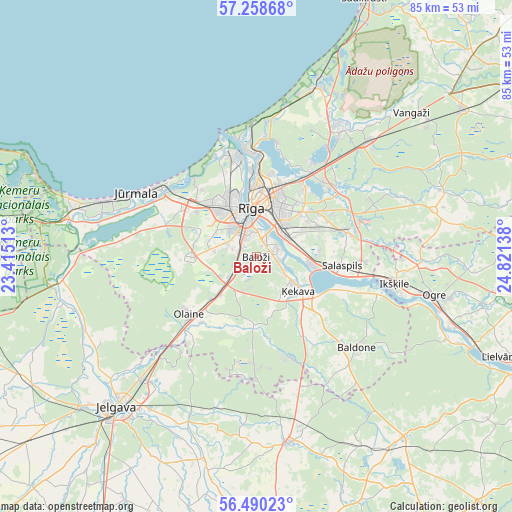
Baloži GPS coordinates[2]
56° 52' 35.148" North, 24° 7' 5.7" East
| Map corner | latitude | longitude |
|---|---|---|
| Upper-left | 57.25868°, | 23.41513° |
| Center: | 56.87643°, | 24.11825° |
| Lower-right: | 56.49023°, | 24.82138° |
| Map W x H: | 85.4×85.4 km | = 53.1×53.1mi |
| max Lat: | 57.89752° ⇑53.6% North |
| Baloži: | 56.87643° |
| min Lat: | ⇓46.4% South 55.75284° |
| min Long | Baloži | max Long |
| 21.01085° | 24.11825° | 28.12165° |
| W 34.3%⇐ | ⇒65.7% E |
Elevation
Elevation of Baloži is 18 m = 59 ft, and this is 47.4 m = 156 ft below average elevation for this country.
| Max E: |
212 m = 696 ft | 77.1% |
| Avg. | 65.4 m = 215 ft | |
| Baloži | 18 m = 59 ft | |
Min E: |
2 m = 7 ft | 22.9% |
See also: Latvia elevation on elevation.city.
Geographical zone
Baloži is located in North temperate zone (between Tropic of Cancer and the Arctic Circle). Distance of this North polar circle is 1077.1 km =669.3 mi to North.| Distance of | km | miles | from Baloži |
|---|---|---|---|
| North Pole | 3683 | 2288.5 | to North |
| Arctic Circle | 1077.1 | 669.3 | to North |
| Tropic Cancer | 3718.1 | 2310.3 | to South |
| Equator | 6324.1 | 3929.6 | to South |


Nearby cities:
15 places around Baloži: (largest is in red/bold)
• Baldone
22.6 km =14 mi,  130°
130°
• Berģi
16.4 km =10.2 mi,  41°
41°
• Bolderaja
17.6 km =10.9 mi,  347°
347°
• Daugavgrīva
19.2 km =11.9 mi,  344°
344°
• Jaunciems
18.4 km =11.4 mi,  10°
10°
• Jūrmala
23.4 km =14.5 mi,  295°
295°
• Kalngale
22.7 km =14.1 mi, 6°
• Mežaparks
14 km =8.7 mi, 10°
• Mārupe
5.2 km =3.2 mi,  308°
308°
• Olaine
14.3 km =8.9 mi,  230°
230°
• Piņķi
14.4 km =8.9 mi, 300°
• Riga
7.8 km =4.8 mi, 354°
• Salaspils
15.1 km =9.4 mi,  96°
96°
• Ulbroka
13.1 km =8.1 mi,  59°
59°
• Ķekava
8.8 km =5.5 mi, 129°
Sources, notices
• [Note1] Compared only with cities in Latvia existing in our database
• [Src1] Map data: © OpenStreetMap contributors (CC-BY-SA)
• [Src2] Other city data from geonames.org with taken over terms of usage.
• [Src3] Geographical zone / Annual Mean Temperature by Robert A. Rohde @ Wikipedia
