Bolderaja geodata
Bolderaja (Riga) is a section of populated place; located in Latvia in Europe/Riga (GMT+3) time zone. With population of 14,771 people, there are 13 cities with bigger population in this country. Compared to other cities in Latvia, 62.9% of cities are located further ↓South; 67.1% of cities are located further →East and 89.3% of cities have higher elevation than Bolderaja. Note1


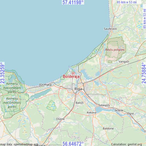
Bolderaja GPS coordinates[2]
57° 1' 52.752" North, 24° 3' 20.556" East
| Map corner | latitude | longitude |
|---|---|---|
| Upper-left | 57.41198°, | 23.35259° |
| Center: | 57.03132°, | 24.05571° |
| Lower-right: | 56.64672°, | 24.75884° |
| Map W x H: | 85.1×85.1 km | = 52.9×52.9mi |
| max Lat: | 57.89752° ⇑37.1% North |
| Bolderaja: | 57.03132° |
| min Lat: | ⇓62.9% South 55.75284° |
| min Long | Bolderaja | max Long |
| 21.01085° | 24.05571° | 28.12165° |
| W 32.9%⇐ | ⇒67.1% E |
Elevation
Elevation of Bolderaja is 7 m = 23 ft, and this is 58.4 m = 192 ft below average elevation for this country.
| Max E: |
212 m = 696 ft | 89.3% |
| Avg. | 65.4 m = 215 ft | |
| Bolderaja | 7 m = 23 ft | |
Min E: |
2 m = 7 ft | 10.7% |
See also: Latvia elevation on elevation.city.
Geographical zone
Bolderaja is located in North temperate zone (between Tropic of Cancer and the Arctic Circle). Distance of this North polar circle is 1059.9 km =658.6 mi to North.| Distance of | km | miles | from Bolderaja |
|---|---|---|---|
| North Pole | 3665.8 | 2277.8 | to North |
| Arctic Circle | 1059.9 | 658.6 | to North |
| Tropic Cancer | 3735.4 | 2321.1 | to South |
| Equator | 6341.3 | 3940.3 | to South |


Nearby cities:
15 places around Bolderaja: (largest is in red/bold)
• Baloži
17.6 km =10.9 mi,  167°
167°
• Berģi
15.6 km =9.7 mi,  108°
108°
• Carnikava
17.6 km =10.9 mi,  51°
51°
• Daugavgrīva
1.8 km =1.1 mi,  317°
317°
• Garkalne
22.1 km =13.7 mi,  86°
86°
• Jaunciems
7.2 km =4.5 mi,  83°
83°
• Jūrmala
18.7 km =11.6 mi,  247°
247°
• Kalngale
8.2 km =5.1 mi, 49°
• Mežaparks
7.2 km =4.5 mi,  118°
118°
• Mārupe
14 km =8.7 mi,  181°
181°
• Piņķi
13.2 km =8.2 mi,  220°
220°
• Riga
10 km =6.2 mi,  162°
162°
• Ulbroka
18.4 km =11.4 mi,  125°
125°
• Ādaži
17.6 km =10.9 mi, 75°
• Ķekava
25.1 km =15.6 mi, 155°
Sources, notices
• [Note1] Compared only with cities in Latvia existing in our database
• [Src1] Map data: © OpenStreetMap contributors (CC-BY-SA)
• [Src2] Other city data from geonames.org with taken over terms of usage.
• [Src3] Geographical zone / Annual Mean Temperature by Robert A. Rohde @ Wikipedia
