Jūrmala geodata
Jūrmala is a seat of a first-order administrative division; located in Latvia in Europe/Riga (GMT+3) time zone. With population of 54,088 people, there are 4 cities with bigger population in this country. Compared to other cities in Latvia, 55% of cities are located further ↓South; 72.9% of cities are located further →East and 93.6% of cities have higher elevation than Jūrmala. Note1


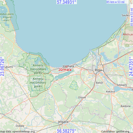
Jūrmala GPS coordinates[2]
56° 58' 4.8" North, 23° 46' 13.368" East
| Map corner | latitude | longitude |
|---|---|---|
| Upper-left | 57.34931°, | 23.06726° |
| Center: | 56.968°, | 23.77038° |
| Lower-right: | 56.58275°, | 24.47351° |
| Map W x H: | 85.2×85.2 km | = 52.9×52.9mi |
| max Lat: | 57.89752° ⇑45% North |
| Jūrmala: | 56.968° |
| min Lat: | ⇓55% South 55.75284° |
| min Long | Jūrmala | max Long |
| 21.01085° | 23.77038° | 28.12165° |
| W 27.1%⇐ | ⇒72.9% E |
Elevation
Elevation of Jūrmala is 6 m = 20 ft, and this is 59.4 m = 195 ft below average elevation for this country.
| Max E: |
212 m = 696 ft | 93.6% |
| Avg. | 65.4 m = 215 ft | |
| Jūrmala | 6 m = 20 ft | |
Min E: |
2 m = 7 ft | 6.4% |
See also: Jūrmala elevation on elevation.city.
Geographical zone
Jūrmala is located in North temperate zone (between Tropic of Cancer and the Arctic Circle). Distance of this North polar circle is 1066.9 km =662.9 mi to North.| Distance of | km | miles | from Jūrmala |
|---|---|---|---|
| North Pole | 3672.8 | 2282.2 | to North |
| Arctic Circle | 1066.9 | 662.9 | to North |
| Tropic Cancer | 3728.3 | 2316.7 | to South |
| Equator | 6334.2 | 3935.9 | to South |


Nearby cities:
15 places around Jūrmala: (largest is in red/bold)
• Baloži
23.4 km =14.5 mi,  115°
115°
• Bolderaja
18.7 km =11.6 mi,  67°
67°
• Daugavgrīva
18.1 km =11.2 mi,  62°
62°
• Jaunciems
25.7 km =16 mi, 72°
• Kalngale
26.6 km =16.5 mi, 62°
• Mežaparks
23.9 km =14.9 mi,  81°
81°
• Mārupe
18.4 km =11.4 mi,  112°
112°
• Olaine
21.7 km =13.5 mi,  152°
152°
• Ozolnieki
30.9 km =19.2 mi,  179°
179°
• Piņķi
9.2 km =5.7 mi, 108°
• Ragaciems
17.7 km =11 mi,  289°
289°
• Riga
20.5 km =12.7 mi,  96°
96°
• Smārde
26.3 km =16.3 mi,  266°
266°
• Tīreļi
18 km =11.2 mi,  217°
217°
• Ķekava
32 km =19.9 mi, 119°
In other languages:
- In France: Jurmala
- In German: Riga-Strand, Jūrmala, Rigastrand
- In Russian: Юрмала
Sources, notices
• [Note1] Compared only with cities in Latvia existing in our database
• [Src1] Map data: © OpenStreetMap contributors (CC-BY-SA)
• [Src2] Other city data from geonames.org with taken over terms of usage.
• [Src3] Geographical zone / Annual Mean Temperature by Robert A. Rohde @ Wikipedia
