Piņķi geodata
Piņķi (Babīte) is a seat of a first-order administrative division; located in Latvia in Europe/Riga (GMT+3) time zone. With population of 3,033 people, there are 53 cities with bigger population in this country. Compared to other cities in Latvia, 50.7% of cities are located further ↓South; 71.4% of cities are located further →East and 93.6% of cities have higher elevation than Piņķi. Note1


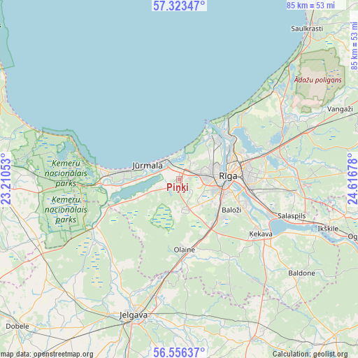
Piņķi GPS coordinates[2]
56° 56' 30.804" North, 23° 54' 49.14" East
| Map corner | latitude | longitude |
|---|---|---|
| Upper-left | 57.32347°, | 23.21053° |
| Center: | 56.94189°, | 23.91365° |
| Lower-right: | 56.55637°, | 24.61678° |
| Map W x H: | 85.3×85.3 km | = 53×53mi |
| max Lat: | 57.89752° ⇑49.3% North |
| Piņķi: | 56.94189° |
| min Lat: | ⇓50.7% South 55.75284° |
| min Long | Piņķi | max Long |
| 21.01085° | 23.91365° | 28.12165° |
| W 28.6%⇐ | ⇒71.4% E |
Elevation
Elevation of Piņķi is 6 m = 20 ft, and this is 59.4 m = 195 ft below average elevation for this country.
| Max E: |
212 m = 696 ft | 93.6% |
| Avg. | 65.4 m = 215 ft | |
| Piņķi | 6 m = 20 ft | |
Min E: |
2 m = 7 ft | 6.4% |
See also: Latvia elevation on elevation.city.
Geographical zone
Piņķi is located in North temperate zone (between Tropic of Cancer and the Arctic Circle). Distance of this North polar circle is 1069.8 km =664.7 mi to North.| Distance of | km | miles | from Piņķi |
|---|---|---|---|
| North Pole | 3675.7 | 2284 | to North |
| Arctic Circle | 1069.8 | 664.7 | to North |
| Tropic Cancer | 3725.4 | 2314.9 | to South |
| Equator | 6331.3 | 3934.1 | to South |


Nearby cities:
15 places around Piņķi: (largest is in red/bold)
• Baloži
14.4 km =8.9 mi,  120°
120°
• Berģi
23.9 km =14.9 mi,  78°
78°
• Bolderaja
13.2 km =8.2 mi,  40°
40°
• Daugavgrīva
13.5 km =8.4 mi,  33°
33°
• Jaunciems
19.1 km =11.9 mi,  55°
55°
• Jūrmala
9.2 km =5.7 mi,  288°
288°
• Kalngale
21.3 km =13.2 mi, 44°
• Mežaparks
16.3 km =10.1 mi,  66°
66°
• Mārupe
9.3 km =5.8 mi, 115°
• Olaine
16.4 km =10.2 mi,  175°
175°
• Ragaciems
26.9 km =16.7 mi, 289°
• Riga
11.7 km =7.3 mi,  87°
87°
• Tīreļi
22.7 km =14.1 mi,  240°
240°
• Ulbroka
23.7 km =14.7 mi, 91°
• Ķekava
23.1 km =14.4 mi, 123°
Sources, notices
• [Note1] Compared only with cities in Latvia existing in our database
• [Src1] Map data: © OpenStreetMap contributors (CC-BY-SA)
• [Src2] Other city data from geonames.org with taken over terms of usage.
• [Src3] Geographical zone / Annual Mean Temperature by Robert A. Rohde @ Wikipedia
