Tata geodata
Tata (Souss-Massa) is a seat of a third-order administrative division; located in Morocco in Africa/Casablanca (GMT+1) time zone. In our database, there are 108 cities with bigger population. Compared to other cities in Morocco, 95% of cities are located further ↑North; 77.9% of cities are located further →East and 59.7% of cities have lower elevation than Tata. Note1


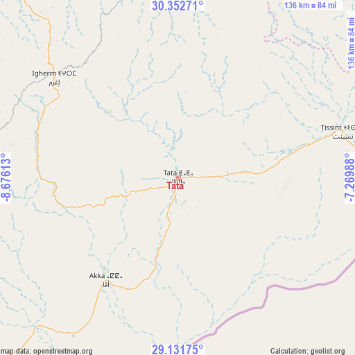
Tata GPS coordinates[2]
29° 44' 38.724" North, 7° 58' 22.8" West
| Map corner | latitude | longitude |
|---|---|---|
| Upper-left | 30.35271°, | -8.67613° |
| Center: | 29.74409°, | -7.973° |
| Lower-right: | 29.13175°, | -7.26988° |
| Map W x H: | 135.8×135.8 km | = 84.4×84.4mi |
| max Lat: | 35.84906° ⇑95% North |
| Tata: | 29.74409° |
| min Lat: | ⇓5% South 22.6558° |
| min Long | Tata | max Long |
| -15.60719° | -7.973° | -1.22855° |
| W 22.1%⇐ | ⇒77.9% E |
Elevation
Elevation of Tata is 684 m = 2244 ft, and this is 67.2 m = 220 ft above average elevation for this country.
| Max E: |
2637 m = 8652 ft | 40.3% |
| Tata | 684 m 2244 ft | |
| Avg. | 616.8 m = 2024 ft | |
Min E: |
1 m = 3 ft | 59.7% |
See also: Morocco elevation on elevation.city.
Geographical zone
Tata is located in North temperate zone (between Tropic of Cancer and the Arctic Circle). Distance of this Northern Tropic circle is 701.3 km =435.8 mi to South.| Distance of | km | miles | from Tata |
|---|---|---|---|
| North Pole | 6699.8 | 4163.1 | to North |
| Arctic Circle | 4093.9 | 2543.8 | to North |
| Tropic Cancer | 701.3 | 435.8 | to South |
| Equator | 3307.2 | 2055 | to South |


Nearby cities:
15 places around Tata: (largest is in red/bold)
• Adar
58.6 km =36.4 mi,  318°
318°
• Agadir Melloul
56.1 km =34.9 mi,  17°
17°
• Amalou
89.8 km =55.8 mi,  303°
303°
• Aoulouz
105.2 km =65.4 mi,  349°
349°
• Arazane
104.1 km =64.7 mi, 324°
• Assads
101.1 km =62.8 mi, 302°
• Tabia
92.9 km =57.7 mi,  290°
290°
• Tafraout
96.7 km =60.1 mi,  268°
268°
• Taliouine
87.5 km =54.4 mi,  3°
3°
• Tanalt
115.4 km =71.7 mi, 271°
• Tarsouat
103.4 km =64.2 mi,  259°
259°
• Tazemmourt
110.6 km =68.7 mi,  311°
311°
• Taznakht
118.7 km =73.8 mi,  38°
38°
• Tiout
99.9 km =62.1 mi, 315°
• Zawit Al Bour
105.3 km =65.4 mi, 349°
Sources, notices
• [Note1] Compared only with cities in Morocco existing in our database
• [Src1] Map data: © OpenStreetMap contributors (CC-BY-SA)
• [Src2] Other city data from geonames.org with taken over terms of usage.
• [Src3] Geographical zone / Annual Mean Temperature by Robert A. Rohde @ Wikipedia
