Amalou geodata
Amalou (Souss-Massa) is a seat of a third-order administrative division; located in Morocco in Africa/Casablanca (GMT+1) time zone. In our database, there are 108 cities with bigger population. Compared to other cities in Morocco, 93% of cities are located further ↑North; 85.3% of cities are located further →East and 83.3% of cities have lower elevation than Amalou. Note1


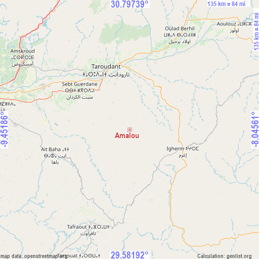
Amalou GPS coordinates[2]
30° 11' 29.508" North, 8° 44' 55.428" West
| Map corner | latitude | longitude |
|---|---|---|
| Upper-left | 30.79739°, | -9.45186° |
| Center: | 30.19153°, | -8.74873° |
| Lower-right: | 29.58192°, | -8.04561° |
| Map W x H: | 135.1×135.1 km | = 83.9×83.9mi |
| max Lat: | 35.84906° ⇑93% North |
| Amalou: | 30.19153° |
| min Lat: | ⇓7% South 22.6558° |
| min Long | Amalou | max Long |
| -15.60719° | -8.74873° | -1.22855° |
| W 14.7%⇐ | ⇒85.3% E |
Elevation
Elevation of Amalou is 1162 m = 3812 ft, and this is 545.2 m = 1789 ft above average elevation for this country.
| Max E: |
2637 m = 8652 ft | 16.7% |
| Amalou | 1162 m 3812 ft | |
| Avg. | 616.8 m = 2024 ft | |
Min E: |
1 m = 3 ft | 83.3% |
See also: Morocco elevation on elevation.city.
Geographical zone
Amalou is located in North temperate zone (between Tropic of Cancer and the Arctic Circle). Distance of this Northern Tropic circle is 751.1 km =466.7 mi to South.| Distance of | km | miles | from Amalou |
|---|---|---|---|
| North Pole | 6650.1 | 4132.2 | to North |
| Arctic Circle | 4044.2 | 2512.9 | to North |
| Tropic Cancer | 751.1 | 466.7 | to South |
| Equator | 3357 | 2085.9 | to South |


Nearby cities:
15 places around Amalou: (largest is in red/bold)
• Adar
36.6 km =22.7 mi,  98°
98°
• Aoulouz
76.4 km =47.5 mi,  45°
45°
• Arazane
37.3 km =23.2 mi,  21°
21°
• Argana
74.7 km =46.4 mi,  331°
331°
• Assads
11.5 km =7.1 mi,  291°
291°
• Bigoudine
73.9 km =45.9 mi,  323°
323°
• Oulad Teïma
49.6 km =30.8 mi,  297°
297°
• Tabia
21.4 km =13.3 mi,  215°
215°
• Tafraout
56.3 km =35 mi,  202°
202°
• Tanalt
61.4 km =38.2 mi, 221°
• Taroudant
33.3 km =20.7 mi,  338°
338°
• Tarsouat
72.9 km =45.3 mi, 201°
• Tazemmourt
25.3 km =15.7 mi, 342°
• Tiout
22.5 km =14 mi,  13°
13°
• Zawit Al Bour
76.9 km =47.8 mi, 45°
Sources, notices
• [Note1] Compared only with cities in Morocco existing in our database
• [Src1] Map data: © OpenStreetMap contributors (CC-BY-SA)
• [Src2] Other city data from geonames.org with taken over terms of usage.
• [Src3] Geographical zone / Annual Mean Temperature by Robert A. Rohde @ Wikipedia
