Agadir Melloul geodata
Agadir Melloul (Souss-Massa) is a seat of a third-order administrative division; located in Morocco in Africa/Casablanca (GMT+1) time zone. In our database, there are 108 cities with bigger population. Compared to other cities in Morocco, 92.6% of cities are located further ↑North; 74.4% of cities are located further →East and 97.3% of cities have lower elevation than Agadir Melloul. Note1


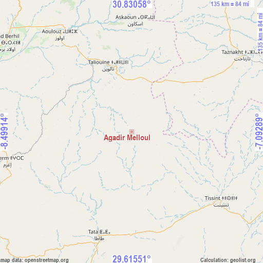
Agadir Melloul GPS coordinates[2]
30° 13' 29.712" North, 7° 47' 45.636" West
| Map corner | latitude | longitude |
|---|---|---|
| Upper-left | 30.83058°, | -8.49914° |
| Center: | 30.22492°, | -7.79601° |
| Lower-right: | 29.61551°, | -7.09289° |
| Map W x H: | 135.1×135.1 km | = 83.9×83.9mi |
| max Lat: | 35.84906° ⇑92.6% North |
| Agadir Melloul: | 30.22492° |
| min Lat: | ⇓7.4% South 22.6558° |
| min Long | Agadir Melloul | max Long |
| -15.60719° | -7.79601° | -1.22855° |
| W 25.6%⇐ | ⇒74.4% E |
Elevation
Elevation of Agadir Melloul is 1766 m = 5794 ft, and this is 1149.2 m = 3770 ft above average elevation for this country.
| Max E: |
2637 m = 8652 ft | 2.7% |
| Agadir Melloul | 1766 m 5794 ft | |
| Avg. | 616.8 m = 2024 ft | |
Min E: |
1 m = 3 ft | 97.3% |
See also: Morocco elevation on elevation.city.
Geographical zone
Agadir Melloul is located in North temperate zone (between Tropic of Cancer and the Arctic Circle). Distance of this Northern Tropic circle is 754.8 km =469 mi to South.| Distance of | km | miles | from Agadir Melloul |
|---|---|---|---|
| North Pole | 6646.4 | 4129.9 | to North |
| Arctic Circle | 4040.5 | 2510.6 | to North |
| Tropic Cancer | 754.8 | 469 | to South |
| Equator | 3360.7 | 2088.2 | to South |


Nearby cities:
15 places around Agadir Melloul: (largest is in red/bold)
• Adar
56.2 km =34.9 mi,  260°
260°
• Amalou
91.6 km =56.9 mi,  267°
267°
• Amerzgane
106.9 km =66.4 mi,  31°
31°
• Aoulouz
62 km =38.5 mi,  323°
323°
• Arazane
83.7 km =52 mi,  291°
291°
• Assads
102.2 km =63.5 mi, 270°
• Iguidi
69 km =42.9 mi,  351°
351°
• Tabia
106.1 km =65.9 mi, 258°
• Taliouine
35.6 km =22.1 mi,  341°
341°
• Taroudant
107.2 km =66.6 mi,  284°
284°
• Tata
56.1 km =34.9 mi,  197°
197°
• Tazemmourt
101.2 km =62.9 mi, 281°
• Taznakht
69.1 km =42.9 mi,  55°
55°
• Tiout
88.3 km =54.9 mi, 281°
• Zawit Al Bour
61.8 km =38.4 mi, 324°
Sources, notices
• [Note1] Compared only with cities in Morocco existing in our database
• [Src1] Map data: © OpenStreetMap contributors (CC-BY-SA)
• [Src2] Other city data from geonames.org with taken over terms of usage.
• [Src3] Geographical zone / Annual Mean Temperature by Robert A. Rohde @ Wikipedia
