Tabia geodata
Tabia (Souss-Massa) is a seat of a third-order administrative division; located in Morocco in Africa/Casablanca (GMT+1) time zone. In our database, there are 108 cities with bigger population. Compared to other cities in Morocco, 93.8% of cities are located further ↑North; 86.8% of cities are located further →East and 82.6% of cities have lower elevation than Tabia. Note1


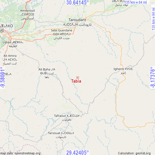
Tabia GPS coordinates[2]
30° 2' 4.632" North, 8° 52' 36.768" West
| Map corner | latitude | longitude |
|---|---|---|
| Upper-left | 30.64145°, | -9.58001° |
| Center: | 30.03462°, | -8.87688° |
| Lower-right: | 29.42405°, | -8.17376° |
| Map W x H: | 135.4×135.4 km | = 84.1×84.1mi |
| max Lat: | 35.84906° ⇑93.8% North |
| Tabia: | 30.03462° |
| min Lat: | ⇓6.2% South 22.6558° |
| min Long | Tabia | max Long |
| -15.60719° | -8.87688° | -1.22855° |
| W 13.2%⇐ | ⇒86.8% E |
Elevation
Elevation of Tabia is 1119 m = 3671 ft, and this is 502.2 m = 1648 ft above average elevation for this country.
| Max E: |
2637 m = 8652 ft | 17.4% |
| Tabia | 1119 m 3671 ft | |
| Avg. | 616.8 m = 2024 ft | |
Min E: |
1 m = 3 ft | 82.6% |
See also: Morocco elevation on elevation.city.
Geographical zone
Tabia is located in North temperate zone (between Tropic of Cancer and the Arctic Circle). Distance of this Northern Tropic circle is 733.6 km =455.8 mi to South.| Distance of | km | miles | from Tabia |
|---|---|---|---|
| North Pole | 6667.5 | 4143 | to North |
| Arctic Circle | 4061.6 | 2523.8 | to North |
| Tropic Cancer | 733.6 | 455.8 | to South |
| Equator | 3339.5 | 2075.1 | to South |


Nearby cities:
15 places around Tabia: (largest is in red/bold)
• Adar
50 km =31.1 mi,  76°
76°
• Agadir
81.5 km =50.6 mi,  301°
301°
• Amalou
21.4 km =13.3 mi,  35°
35°
• Arazane
58.2 km =36.2 mi,  26°
26°
• Assads
21.8 km =13.5 mi,  4°
4°
• Dakhla
77.5 km =48.2 mi, 302°
• Inezgane
72.7 km =45.2 mi, 299°
• Ouijjane
78.3 km =48.7 mi,  234°
234°
• Oulad Teïma
51.2 km =31.8 mi,  321°
321°
• Tafraout
35.7 km =22.2 mi,  195°
195°
• Tanalt
40.2 km =25 mi,  224°
224°
• Taroudant
48.4 km =30.1 mi,  359°
359°
• Tarsouat
52.4 km =32.6 mi, 196°
• Tazemmourt
41.8 km =26 mi,  6°
6°
• Tiout
43 km =26.7 mi,  23°
23°
Sources, notices
• [Note1] Compared only with cities in Morocco existing in our database
• [Src1] Map data: © OpenStreetMap contributors (CC-BY-SA)
• [Src2] Other city data from geonames.org with taken over terms of usage.
• [Src3] Geographical zone / Annual Mean Temperature by Robert A. Rohde @ Wikipedia
