Taznakht geodata
Taznakht (Drâa-Tafilalet) is a seat of a third-order administrative division; located in Morocco in Africa/Casablanca (GMT+1) time zone. In our database, there are 108 cities with bigger population. Compared to other cities in Morocco, 87.2% of cities are located further ↑North; 67.1% of cities are located further →East and 89.9% of cities have lower elevation than Taznakht. Note1


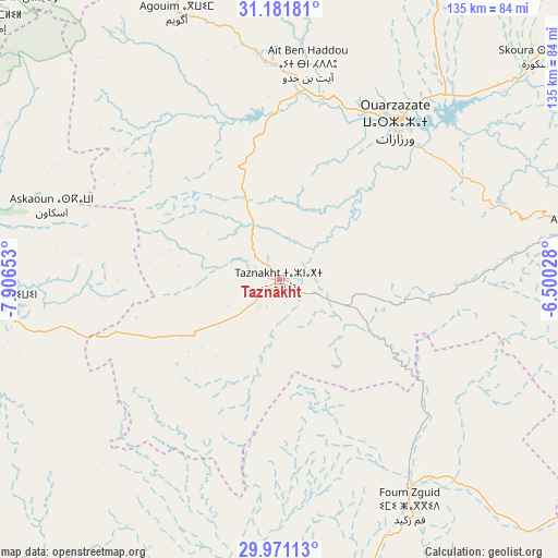
Taznakht GPS coordinates[2]
30° 34' 42.096" North, 7° 12' 12.276" West
| Map corner | latitude | longitude |
|---|---|---|
| Upper-left | 31.18181°, | -7.90653° |
| Center: | 30.57836°, | -7.20341° |
| Lower-right: | 29.97113°, | -6.50028° |
| Map W x H: | 134.6×134.6 km | = 83.6×83.6mi |
| max Lat: | 35.84906° ⇑87.2% North |
| Taznakht: | 30.57836° |
| min Lat: | ⇓12.8% South 22.6558° |
| min Long | Taznakht | max Long |
| -15.60719° | -7.20341° | -1.22855° |
| W 32.9%⇐ | ⇒67.1% E |
Elevation
Elevation of Taznakht is 1405 m = 4610 ft, and this is 788.2 m = 2586 ft above average elevation for this country.
| Max E: |
2637 m = 8652 ft | 10.1% |
| Taznakht | 1405 m 4610 ft | |
| Avg. | 616.8 m = 2024 ft | |
Min E: |
1 m = 3 ft | 89.9% |
See also: Morocco elevation on elevation.city.
Geographical zone
Taznakht is located in North temperate zone (between Tropic of Cancer and the Arctic Circle). Distance of this Northern Tropic circle is 794.1 km =493.4 mi to South.| Distance of | km | miles | from Taznakht |
|---|---|---|---|
| North Pole | 6607.1 | 4105.5 | to North |
| Arctic Circle | 4001.2 | 2486.2 | to North |
| Tropic Cancer | 794.1 | 493.4 | to South |
| Equator | 3400 | 2112.7 | to South |


Nearby cities:
15 places around Taznakht: (largest is in red/bold)
• Agadir Melloul
69.1 km =42.9 mi,  235°
235°
• Agdz
73.6 km =45.7 mi,  79°
79°
• Amerzgane
51.7 km =32.1 mi,  359°
359°
• Aoulouz
94.1 km =58.5 mi,  276°
276°
• Iguidi
72.9 km =45.3 mi,  293°
293°
• Moulay Brahim
107.4 km =66.7 mi,  317°
317°
• Ouarzazat
48.1 km =29.9 mi,  38°
38°
• Oukaïmedene
93.8 km =58.3 mi, 318°
• Setti Fatma
85 km =52.8 mi,  327°
327°
• Skoura
82.2 km =51.1 mi,  49°
49°
• Taliouine
68.1 km =42.3 mi,  265°
265°
• Telouet
79.1 km =49.2 mi, 357°
• Tidili Mesfioua
106.1 km =65.9 mi,  338°
338°
• Zawit Al Bour
93.5 km =58.1 mi, 276°
• Zerkten
98 km =60.9 mi,  349°
349°
Sources, notices
• [Note1] Compared only with cities in Morocco existing in our database
• [Src1] Map data: © OpenStreetMap contributors (CC-BY-SA)
• [Src2] Other city data from geonames.org with taken over terms of usage.
• [Src3] Geographical zone / Annual Mean Temperature by Robert A. Rohde @ Wikipedia
