Amerzgane geodata
Amerzgane (Drâa-Tafilalet) is a seat of a third-order administrative division; located in Morocco in Africa/Casablanca (GMT+1) time zone. In our database, there are 108 cities with bigger population. Compared to other cities in Morocco, 82.2% of cities are located further ↑North; 67.4% of cities are located further →East and 88.4% of cities have lower elevation than Amerzgane. Note1


Amerzgane GPS coordinates[2]
31° 2' 37.32" North, 7° 12' 37.332" West
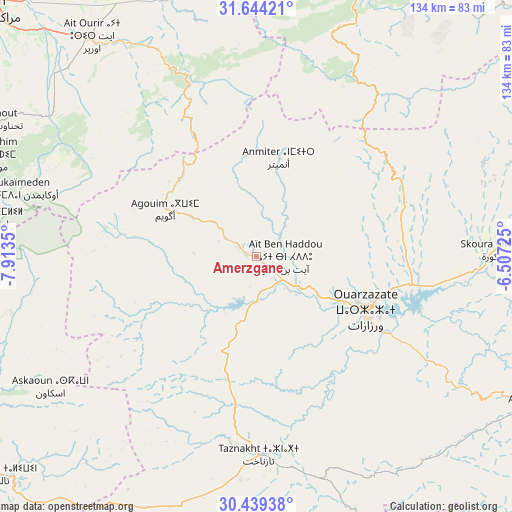
| Map corner | latitude | longitude |
|---|---|---|
| Upper-left | 31.64421°, | -7.9135° |
| Center: | 31.0437°, | -7.21037° |
| Lower-right: | 30.43938°, | -6.50725° |
| Map W x H: | 134×134 km | = 83.3×83.3mi |
| max Lat: | 35.84906° ⇑82.2% North |
| Amerzgane: | 31.0437° |
| min Lat: | ⇓17.8% South 22.6558° |
| min Long | Amerzgane | max Long |
| -15.60719° | -7.21037° | -1.22855° |
| W 32.6%⇐ | ⇒67.4% E |
Elevation
Elevation of Amerzgane is 1321 m = 4334 ft, and this is 704.2 m = 2310 ft above average elevation for this country.
| Max E: |
2637 m = 8652 ft | 11.6% |
| Amerzgane | 1321 m 4334 ft | |
| Avg. | 616.8 m = 2024 ft | |
Min E: |
1 m = 3 ft | 88.4% |
See also: Morocco elevation on elevation.city.
Geographical zone
Amerzgane is located in North temperate zone (between Tropic of Cancer and the Arctic Circle). Distance of this Northern Tropic circle is 845.8 km =525.6 mi to South.| Distance of | km | miles | from Amerzgane |
|---|---|---|---|
| North Pole | 6555.3 | 4073.3 | to North |
| Arctic Circle | 3949.4 | 2454 | to North |
| Tropic Cancer | 845.8 | 525.6 | to South |
| Equator | 3451.7 | 2144.8 | to South |


Nearby cities:
15 places around Amerzgane: (largest is in red/bold)
• Abadou
60.3 km =37.5 mi,  350°
350°
• Demnate
79.2 km =49.2 mi,  14°
14°
• Iguidi
69.9 km =43.4 mi,  250°
250°
• Moulay Brahim
77.1 km =47.9 mi,  290°
290°
• Ouarzazat
33.2 km =20.6 mi,  114°
114°
• Oukaïmedene
64.5 km =40.1 mi, 286°
• Setti Fatma
48.8 km =30.3 mi, 294°
• Sidi Rahhal
71.9 km =44.7 mi,  339°
339°
• Skoura
62.7 km =39 mi,  88°
88°
• Taznakht
51.7 km =32.1 mi,  179°
179°
• Telouet
27.4 km =17 mi, 354°
• Tidili Mesfioua
60.5 km =37.6 mi,  320°
320°
• Tifni
69.8 km =43.4 mi,  21°
21°
• Touama
60.9 km =37.8 mi,  333°
333°
• Zerkten
47.8 km =29.7 mi, 338°
Sources, notices
• [Note1] Compared only with cities in Morocco existing in our database
• [Src1] Map data: © OpenStreetMap contributors (CC-BY-SA)
• [Src2] Other city data from geonames.org with taken over terms of usage.
• [Src3] Geographical zone / Annual Mean Temperature by Robert A. Rohde @ Wikipedia
