Bzou geodata
Bzou (Béni Mellal-Khénifra) is a seat of a third-order administrative division; located in Morocco in Africa/Casablanca (GMT+1) time zone. In our database, there are 108 cities with bigger population. Compared to other cities in Morocco, 64.7% of cities are located further ↑North; 65.5% of cities are located further →East and 50.4% of cities have higher elevation than Bzou. Note1


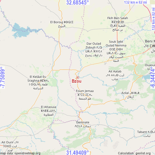
Bzou GPS coordinates[2]
32° 5' 30.156" North, 7° 2' 52.296" West
| Map corner | latitude | longitude |
|---|---|---|
| Upper-left | 32.68545°, | -7.75099° |
| Center: | 32.09171°, | -7.04786° |
| Lower-right: | 31.49409°, | -6.34474° |
| Map W x H: | 132.5×132.5 km | = 82.3×82.3mi |
| max Lat: | 35.84906° ⇑64.7% North |
| Bzou: | 32.09171° |
| min Lat: | ⇓35.3% South 22.6558° |
| min Long | Bzou | max Long |
| -15.60719° | -7.04786° | -1.22855° |
| W 34.5%⇐ | ⇒65.5% E |
Elevation
Elevation of Bzou is 455 m = 1493 ft, and this is 161.8 m = 531 ft below average elevation for this country.
| Max E: |
2637 m = 8652 ft | 50.4% |
| Avg. | 616.8 m = 2024 ft | |
| Bzou | 455 m = 1493 ft | |
Min E: |
1 m = 3 ft | 49.6% |
See also: Morocco elevation on elevation.city.
Geographical zone
Bzou is located in North temperate zone (between Tropic of Cancer and the Arctic Circle). Distance of this Northern Tropic circle is 962.3 km =597.9 mi to South.| Distance of | km | miles | from Bzou |
|---|---|---|---|
| North Pole | 6438.8 | 4000.9 | to North |
| Arctic Circle | 3832.9 | 2381.7 | to North |
| Tropic Cancer | 962.3 | 597.9 | to South |
| Equator | 3568.3 | 2217.2 | to South |


Nearby cities:
15 places around Bzou: (largest is in red/bold)
• Abadou
62.3 km =38.7 mi,  203°
203°
• Al Fqih Ben Çalah
56.8 km =35.3 mi,  36°
36°
• Azilal
47.2 km =29.3 mi,  107°
107°
• Beni Mellal
71.1 km =44.2 mi,  67°
67°
• Dar Ould Zidouh
28 km =17.4 mi,  28°
28°
• Demnate
39.9 km =24.8 mi,  174°
174°
• Ouaoula
37.4 km =23.2 mi,  131°
131°
• Oulad Ayad
26.3 km =16.3 mi,  62°
62°
• Sidi Jaber
67.6 km =42 mi, 60°
• Sidi Moussa
24.7 km =15.3 mi,  324°
324°
• Sidi Rahhal
63.4 km =39.4 mi,  219°
219°
• Tabia
24.4 km =15.2 mi, 106°
• Taounza
41.6 km =25.8 mi,  89°
89°
• Tifni
52.6 km =32.7 mi, 168°
• Timoulilt
56.1 km =34.9 mi,  77°
77°
Sources, notices
• [Note1] Compared only with cities in Morocco existing in our database
• [Src1] Map data: © OpenStreetMap contributors (CC-BY-SA)
• [Src2] Other city data from geonames.org with taken over terms of usage.
• [Src3] Geographical zone / Annual Mean Temperature by Robert A. Rohde @ Wikipedia
