Al Fqih Ben Çalah geodata
Al Fqih Ben Çalah (Béni Mellal-Khénifra) is a populated place; located in Morocco in Africa/Casablanca (GMT+1) time zone. With population of 84,072 people, there are 29 cities with bigger population in this country. Compared to other cities in Morocco, 59.3% of cities are located further ↑North; 60.1% of cities are located further →East and 51.9% of cities have higher elevation than Al Fqih Ben Çalah. Note1


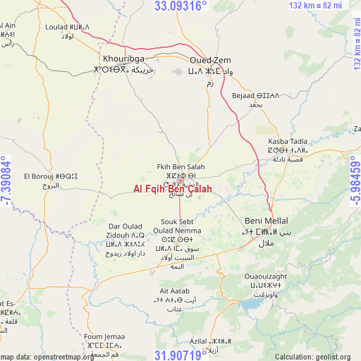
Al Fqih Ben Çalah GPS coordinates[2]
32° 30' 7.668" North, 6° 41' 15.756" West
| Map corner | latitude | longitude |
|---|---|---|
| Upper-left | 33.09316°, | -7.39084° |
| Center: | 32.50213°, | -6.68771° |
| Lower-right: | 31.90719°, | -5.98459° |
| Map W x H: | 131.9×131.9 km | = 82×82mi |
| max Lat: | 35.84906° ⇑59.3% North |
| Al Fqih Ben Çalah: | 32.50213° |
| min Lat: | ⇓40.7% South 22.6558° |
| min Long | Al Fqih Ben Ça | max Long |
| -15.60719° | -6.68771° | -1.22855° |
| W 39.9%⇐ | ⇒60.1% E |
Elevation
Elevation of Al Fqih Ben Çalah is 444 m = 1457 ft, and this is 172.8 m = 567 ft below average elevation for this country.
| Max E: |
2637 m = 8652 ft | 51.9% |
| Avg. | 616.8 m = 2024 ft | |
| Al Fqih Ben Çalah | 444 m = 1457 ft | |
Min E: |
1 m = 3 ft | 48.1% |
See also: Al Fqih Ben Çalah elevation on elevation.city.
Geographical zone
Al Fqih Ben Çalah is located in North temperate zone (between Tropic of Cancer and the Arctic Circle). Distance of this Northern Tropic circle is 1008 km =626.3 mi to South.| Distance of | km | miles | from Al Fqih Ben Çalah |
|---|---|---|---|
| North Pole | 6393.2 | 3972.5 | to North |
| Arctic Circle | 3787.3 | 2353.3 | to North |
| Tropic Cancer | 1008 | 626.3 | to South |
| Equator | 3613.9 | 2245.6 | to South |


Nearby cities:
15 places around Al Fqih Ben Çalah: (largest is in red/bold)
• Azilal
61.1 km =38 mi,  169°
169°
• Beni Mellal
36.6 km =22.7 mi,  120°
120°
• Boujniba
45 km =28 mi,  349°
349°
• Bzou
56.8 km =35.3 mi,  216°
216°
• Dar Ould Zidouh
29.3 km =18.2 mi, 224°
• Isseksi
49.1 km =30.5 mi,  128°
128°
• Kasba Tadla
40.7 km =25.3 mi,  74°
74°
• Khouribga
46.8 km =29.1 mi,  334°
334°
• Oued Zem
41.5 km =25.8 mi,  14°
14°
• Oulad Ayad
35.2 km =21.9 mi,  197°
197°
• Sidi Jaber
28 km =17.4 mi, 116°
• Sidi Moussa
54.6 km =33.9 mi,  242°
242°
• Tabia
53.5 km =33.2 mi,  191°
191°
• Taounza
46.1 km =28.6 mi, 170°
• Timoulilt
39.1 km =24.3 mi,  147°
147°
Sources, notices
• [Note1] Compared only with cities in Morocco existing in our database
• [Src1] Map data: © OpenStreetMap contributors (CC-BY-SA)
• [Src2] Other city data from geonames.org with taken over terms of usage.
• [Src3] Geographical zone / Annual Mean Temperature by Robert A. Rohde @ Wikipedia
