Beni Mellal geodata
Beni Mellal (Béni Mellal-Khénifra) is a seat of a first-order administrative division; located in Morocco in Africa/Casablanca (GMT+1) time zone. With population of 166,399 people, there are 16 cities with bigger population in this country. Compared to other cities in Morocco, 60.1% of cities are located further ↑North; 55.8% of cities are located further →East and 54.3% of cities have lower elevation than Beni Mellal. Note1


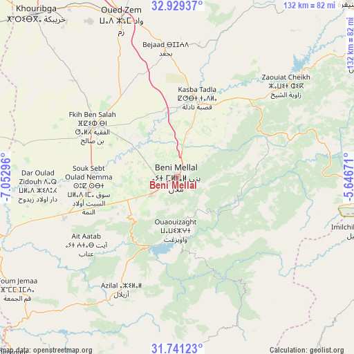
Beni Mellal GPS coordinates[2]
32° 20' 14.1" North, 6° 20' 59.388" West
| Map corner | latitude | longitude |
|---|---|---|
| Upper-left | 32.92937°, | -7.05296° |
| Center: | 32.33725°, | -6.34983° |
| Lower-right: | 31.74123°, | -5.64671° |
| Map W x H: | 132.1×132.1 km | = 82.1×82.1mi |
| max Lat: | 35.84906° ⇑60.1% North |
| Beni Mellal: | 32.33725° |
| min Lat: | ⇓39.9% South 22.6558° |
| min Long | Beni Mellal | max Long |
| -15.60719° | -6.34983° | -1.22855° |
| W 44.2%⇐ | ⇒55.8% E |
Elevation
Elevation of Beni Mellal is 538 m = 1765 ft, and this is 78.8 m = 259 ft below average elevation for this country.
| Max E: |
2637 m = 8652 ft | 45.7% |
| Avg. | 616.8 m = 2024 ft | |
| Beni Mellal | 538 m = 1765 ft | |
Min E: |
1 m = 3 ft | 54.3% |
See also: Beni Mellal elevation on elevation.city.
Geographical zone
Beni Mellal is located in North temperate zone (between Tropic of Cancer and the Arctic Circle). Distance of this Northern Tropic circle is 989.6 km =614.9 mi to South.| Distance of | km | miles | from Beni Mellal |
|---|---|---|---|
| North Pole | 6411.5 | 3983.9 | to North |
| Arctic Circle | 3805.6 | 2364.7 | to North |
| Tropic Cancer | 989.6 | 614.9 | to South |
| Equator | 3595.6 | 2234.2 | to South |


Nearby cities:
15 places around Beni Mellal: (largest is in red/bold)
• Al Fqih Ben Çalah
36.6 km =22.7 mi,  300°
300°
• Anergui
48.8 km =30.3 mi,  127°
127°
• Azilal
46.7 km =29 mi,  206°
206°
• Dar Ould Zidouh
52.2 km =32.4 mi,  266°
266°
• El Ksiba
40.6 km =25.2 mi,  49°
49°
• Isseksi
13.8 km =8.6 mi,  150°
150°
• Kasba Tadla
29.9 km =18.6 mi,  14°
14°
• Ouaoula
64.2 km =39.9 mi,  215°
215°
• Oued Zem
62.1 km =38.6 mi,  340°
340°
• Oulad Ayad
45 km =28 mi,  250°
250°
• Sidi Jaber
8.9 km =5.5 mi,  311°
311°
• Tabia
54.4 km =33.8 mi,  231°
231°
• Taounza
36.3 km =22.6 mi, 221°
• Timoulilt
18.5 km =11.5 mi, 216°
• Zawyat ech Cheïkh
53 km =32.9 mi, 49°
In other languages:
- In Spanish: Beni Melal
- In France: Béni Mellal
- In German: Beni-Mellal
- In Italian: Béni Mellal
- In Russian: Бени-Меллаль
- In Chinese: 貝尼邁拉勒
Sources, notices
• [Note1] Compared only with cities in Morocco existing in our database
• [Src1] Map data: © OpenStreetMap contributors (CC-BY-SA)
• [Src2] Other city data from geonames.org with taken over terms of usage.
• [Src3] Geographical zone / Annual Mean Temperature by Robert A. Rohde @ Wikipedia
