Tabia geodata
Tabia (Béni Mellal-Khénifra) is a seat of a third-order administrative division; located in Morocco in Africa/Casablanca (GMT+1) time zone. In our database, there are 108 cities with bigger population. Compared to other cities in Morocco, 65.5% of cities are located further ↑North; 61.6% of cities are located further →East and 55.4% of cities have lower elevation than Tabia. Note1


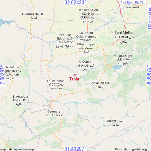
Tabia GPS coordinates[2]
32° 1' 48.324" North, 6° 47' 59.46" West
| Map corner | latitude | longitude |
|---|---|---|
| Upper-left | 32.62423°, | -7.50297° |
| Center: | 32.03009°, | -6.79985° |
| Lower-right: | 31.43207°, | -6.09672° |
| Map W x H: | 132.6×132.6 km | = 82.4×82.4mi |
| max Lat: | 35.84906° ⇑65.5% North |
| Tabia: | 32.03009° |
| min Lat: | ⇓34.5% South 22.6558° |
| min Long | Tabia | max Long |
| -15.60719° | -6.79985° | -1.22855° |
| W 38.4%⇐ | ⇒61.6% E |
Elevation
Elevation of Tabia is 561 m = 1841 ft, and this is 55.8 m = 183 ft below average elevation for this country.
| Max E: |
2637 m = 8652 ft | 44.6% |
| Avg. | 616.8 m = 2024 ft | |
| Tabia | 561 m = 1841 ft | |
Min E: |
1 m = 3 ft | 55.4% |
See also: Morocco elevation on elevation.city.
Geographical zone
Tabia is located in North temperate zone (between Tropic of Cancer and the Arctic Circle). Distance of this Northern Tropic circle is 955.5 km =593.7 mi to South.| Distance of | km | miles | from Tabia |
|---|---|---|---|
| North Pole | 6445.6 | 4005.1 | to North |
| Arctic Circle | 3839.8 | 2385.9 | to North |
| Tropic Cancer | 955.5 | 593.7 | to South |
| Equator | 3561.4 | 2213 | to South |


Nearby cities:
15 places around Tabia: (largest is in red/bold)
• Al Fqih Ben Çalah
53.5 km =33.2 mi,  11°
11°
• Azilal
22.9 km =14.2 mi,  109°
109°
• Beni Mellal
54.4 km =33.8 mi,  51°
51°
• Bzou
24.4 km =15.2 mi,  286°
286°
• Dar Ould Zidouh
32.9 km =20.4 mi,  342°
342°
• Demnate
38.2 km =23.7 mi,  210°
210°
• Isseksi
54 km =33.6 mi,  65°
65°
• Ouaoula
18.4 km =11.4 mi,  165°
165°
• Oulad Ayad
18.9 km =11.7 mi,  359°
359°
• Sidi Jaber
53.6 km =33.3 mi,  41°
41°
• Sidi Moussa
46.4 km =28.8 mi,  305°
305°
• Tabant
55.8 km =34.7 mi,  138°
138°
• Taounza
19.6 km =12.2 mi, 68°
• Tifni
46.7 km =29 mi,  196°
196°
• Timoulilt
36.8 km =22.9 mi,  58°
58°
Sources, notices
• [Note1] Compared only with cities in Morocco existing in our database
• [Src1] Map data: © OpenStreetMap contributors (CC-BY-SA)
• [Src2] Other city data from geonames.org with taken over terms of usage.
• [Src3] Geographical zone / Annual Mean Temperature by Robert A. Rohde @ Wikipedia
