Ouaoula geodata
Ouaoula (Béni Mellal-Khénifra) is a seat of a third-order administrative division; located in Morocco in Africa/Casablanca (GMT+1) time zone. In our database, there are 108 cities with bigger population. Compared to other cities in Morocco, 67.4% of cities are located further ↑North; 60.5% of cities are located further →East and 86.8% of cities have lower elevation than Ouaoula. Note1


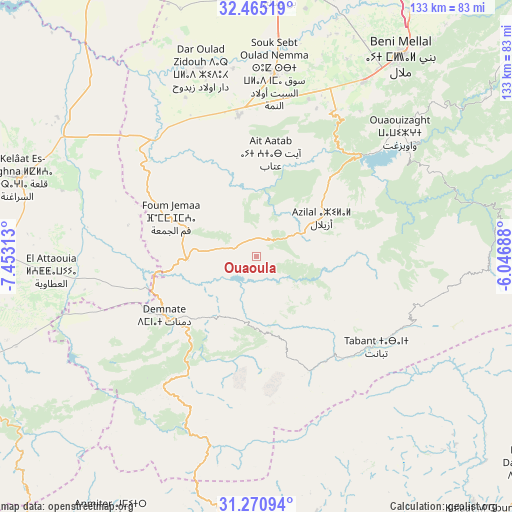
Ouaoula GPS coordinates[2]
31° 52' 12" North, 6° 45' 0" West
| Map corner | latitude | longitude |
|---|---|---|
| Upper-left | 32.46519°, | -7.45313° |
| Center: | 31.87°, | -6.75° |
| Lower-right: | 31.27094°, | -6.04688° |
| Map W x H: | 132.8×132.8 km | = 82.5×82.5mi |
| max Lat: | 35.84906° ⇑67.4% North |
| Ouaoula: | 31.87° |
| min Lat: | ⇓32.6% South 22.6558° |
| min Long | Ouaoula | max Long |
| -15.60719° | -6.75° | -1.22855° |
| W 39.5%⇐ | ⇒60.5% E |
Elevation
Elevation of Ouaoula is 1237 m = 4058 ft, and this is 620.2 m = 2035 ft above average elevation for this country.
| Max E: |
2637 m = 8652 ft | 13.2% |
| Ouaoula | 1237 m 4058 ft | |
| Avg. | 616.8 m = 2024 ft | |
Min E: |
1 m = 3 ft | 86.8% |
See also: Morocco elevation on elevation.city.
Geographical zone
Ouaoula is located in North temperate zone (between Tropic of Cancer and the Arctic Circle). Distance of this Northern Tropic circle is 937.7 km =582.7 mi to South.| Distance of | km | miles | from Ouaoula |
|---|---|---|---|
| North Pole | 6463.5 | 4016.2 | to North |
| Arctic Circle | 3857.6 | 2397 | to North |
| Tropic Cancer | 937.7 | 582.7 | to South |
| Equator | 3543.6 | 2201.9 | to South |


Nearby cities:
15 places around Ouaoula: (largest is in red/bold)
• Abadou
62.3 km =38.7 mi,  238°
238°
• Azilal
19.7 km =12.2 mi,  58°
58°
• Beni Mellal
64.2 km =39.9 mi,  35°
35°
• Bzou
37.4 km =23.2 mi,  311°
311°
• Dar Ould Zidouh
51.3 km =31.9 mi,  343°
343°
• Demnate
28.4 km =17.6 mi, 237°
• Ifrane
42.2 km =26.2 mi,  116°
116°
• Isseksi
59.9 km =37.2 mi,  48°
48°
• Oulad Ayad
37 km =23 mi,  352°
352°
• Sidi Moussa
61.7 km =38.3 mi,  316°
316°
• Tabant
40.2 km =25 mi,  126°
126°
• Tabia
18.4 km =11.4 mi, 345°
• Taounza
28.3 km =17.6 mi,  28°
28°
• Tifni
32.4 km =20.1 mi,  213°
213°
• Timoulilt
45.7 km =28.4 mi, 35°
Sources, notices
• [Note1] Compared only with cities in Morocco existing in our database
• [Src1] Map data: © OpenStreetMap contributors (CC-BY-SA)
• [Src2] Other city data from geonames.org with taken over terms of usage.
• [Src3] Geographical zone / Annual Mean Temperature by Robert A. Rohde @ Wikipedia
