Slobozia geodata
Slobozia (Transnistria) is a populated place; located in Moldova in Europe/Chisinau (GMT+3) time zone. With population of 15,356 people, there are 19 cities with bigger population in this country. Compared to other cities in Moldova, 75.3% of cities are located further ↑North; 95.9% of cities are located further ←West and 93.2% of cities have higher elevation than Slobozia. Note1


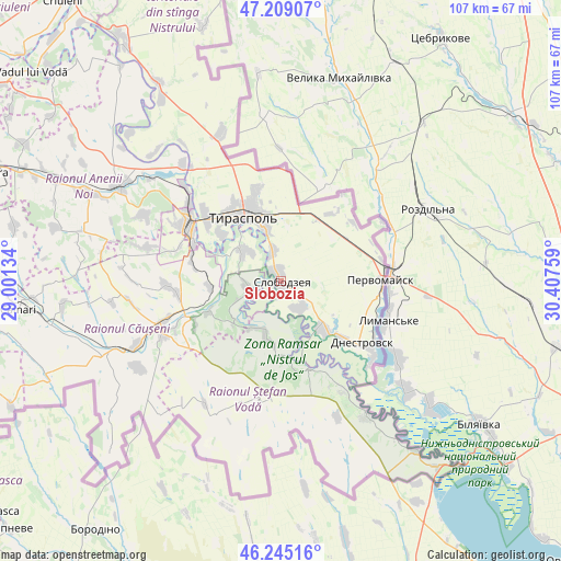
Slobozia GPS coordinates[2]
46° 43' 45.372" North, 29° 42' 16.056" East
| Map corner | latitude | longitude |
|---|---|---|
| Upper-left | 47.20907°, | 29.00134° |
| Center: | 46.72927°, | 29.70446° |
| Lower-right: | 46.24516°, | 30.40759° |
| Map W x H: | 107.2×107.2 km | = 66.6×66.6mi |
| max Lat: | 48.43285° ⇑75.3% North |
| Slobozia: | 46.72927° |
| min Lat: | ⇓24.7% South 45.48167° |
| min Long | Slobozia | max Long |
| 27.07787° | 29.70446° | 29.9617° |
| W 95.9%⇐ | ⇒4.1% E |
Elevation
Elevation of Slobozia is 24 m = 79 ft, and this is 68.8 m = 226 ft below average elevation for this country.
| Max E: |
241 m = 791 ft | 93.2% |
| Avg. | 92.8 m = 304 ft | |
| Slobozia | 24 m = 79 ft | |
Min E: |
11 m = 36 ft | 6.8% |
See also: Moldova elevation on elevation.city.
Geographical zone
Slobozia is located in North temperate zone (between Tropic of Cancer and the Arctic Circle). Distance of this North polar circle is 2205.4 km =1370.4 mi to North.| Distance of | km | miles | from Slobozia |
|---|---|---|---|
| North Pole | 4811.3 | 2989.6 | to North |
| Arctic Circle | 2205.4 | 1370.4 | to North |
| Tropic Cancer | 2589.9 | 1609.3 | to South |
| Equator | 5195.8 | 3228.5 | to South |


Nearby cities:
15 places around Slobozia: (largest is in red/bold)
• Anenii Noi
39.4 km =24.5 mi,  294°
294°
• Bender
20.7 km =12.9 mi,  303°
303°
• Chiţcani
9 km =5.6 mi,  311°
311°
• Crasnoe
11.8 km =7.3 mi,  139°
139°
• Căuşeni
24.6 km =15.3 mi,  245°
245°
• Dnestrovsc
20.6 km =12.8 mi,  127°
127°
• Hryhoriopol
56.3 km =35 mi,  326°
326°
• Maiac
61.5 km =38.2 mi,  336°
336°
• Pervomaisc
19.6 km =12.2 mi,  88°
88°
• Sîngera
59.8 km =37.2 mi, 290°
• Tiraspol
13.9 km =8.6 mi, 335°
• Tiraspolul Nou
17.8 km =11.1 mi, 308°
• Vadul lui Vodă
62.4 km =38.8 mi, 310°
• Varniţa
23.7 km =14.7 mi, 310°
• Ştefan Vodă
24.3 km =15.1 mi,  187°
187°
Sources, notices
• [Note1] Compared only with cities in Moldova existing in our database
• [Src1] Map data: © OpenStreetMap contributors (CC-BY-SA)
• [Src2] Other city data from geonames.org with taken over terms of usage.
• [Src3] Geographical zone / Annual Mean Temperature by Robert A. Rohde @ Wikipedia
