Pervomaisc geodata
Pervomaisc (Transnistria) is a populated place; located in Moldova in Europe/Chisinau (GMT+3) time zone. With population of 7,300 people, there are 47 cities with bigger population in this country. Compared to other cities in Moldova, 74% of cities are located further ↑North; 100% of cities are located further ←West and 98.6% of cities have higher elevation than Pervomaisc. Note1


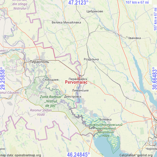
Pervomaisc GPS coordinates[2]
46° 43' 57.108" North, 29° 57' 42.12" East
| Map corner | latitude | longitude |
|---|---|---|
| Upper-left | 47.2123°, | 29.25858° |
| Center: | 46.73253°, | 29.9617° |
| Lower-right: | 46.24845°, | 30.66483° |
| Map W x H: | 107.2×107.2 km | = 66.6×66.6mi |
| max Lat: | 48.43285° ⇑74% North |
| Pervomaisc: | 46.73253° |
| min Lat: | ⇓26% South 45.48167° |
| min Long | Pervomaisc | max Long |
| 27.07787° | 29.9617° | 29.9617° |
| W 100%⇐ | ⇒0% E |
Elevation
Elevation of Pervomaisc is 12 m = 39 ft, and this is 80.8 m = 265 ft below average elevation for this country.
| Max E: |
241 m = 791 ft | 98.6% |
| Avg. | 92.8 m = 304 ft | |
| Pervomaisc | 12 m = 39 ft | |
Min E: |
11 m = 36 ft | 1.4% |
See also: Moldova elevation on elevation.city.
Geographical zone
Pervomaisc is located in North temperate zone (between Tropic of Cancer and the Arctic Circle). Distance of this North polar circle is 2205 km =1370.1 mi to North.| Distance of | km | miles | from Pervomaisc |
|---|---|---|---|
| North Pole | 4810.9 | 2989.4 | to North |
| Arctic Circle | 2205 | 1370.1 | to North |
| Tropic Cancer | 2590.3 | 1609.5 | to South |
| Equator | 5196.2 | 3228.8 | to South |


Nearby cities:
15 places around Pervomaisc: (largest is in red/bold)
• Anenii Noi
57.6 km =35.8 mi,  286°
286°
• Bender
38.5 km =23.9 mi, 286°
• Chiţcani
26.9 km =16.7 mi,  282°
282°
• Crasnoe
15.2 km =9.4 mi,  232°
232°
• Căuşeni
43.3 km =26.9 mi,  255°
255°
• Dnestrovsc
13.3 km =8.3 mi,  194°
194°
• Hryhoriopol
68.7 km =42.7 mi,  313°
313°
• Maiac
71.2 km =44.2 mi,  322°
322°
• Slobozia
19.6 km =12.2 mi,  268°
268°
• Sîngera
78.4 km =48.7 mi, 285°
• Tiraspol
28.1 km =17.5 mi,  295°
295°
• Tiraspolul Nou
35.2 km =21.9 mi, 287°
• Vadul lui Vodă
78.2 km =48.6 mi, 300°
• Varniţa
40.5 km =25.2 mi, 291°
• Ştefan Vodă
33.5 km =20.8 mi,  223°
223°
Sources, notices
• [Note1] Compared only with cities in Moldova existing in our database
• [Src1] Map data: © OpenStreetMap contributors (CC-BY-SA)
• [Src2] Other city data from geonames.org with taken over terms of usage.
• [Src3] Geographical zone / Annual Mean Temperature by Robert A. Rohde @ Wikipedia
