Crasnoe geodata
Crasnoe (Transnistria) is a populated place; located in Moldova in Europe/Chisinau (GMT+3) time zone. With population of 4,200 people, there are 58 cities with bigger population in this country. Compared to other cities in Moldova, 76.7% of cities are located further ↑North; 97.3% of cities are located further ←West and 97.3% of cities have higher elevation than Crasnoe. Note1


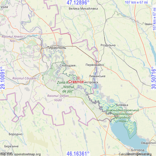
Crasnoe GPS coordinates[2]
46° 38' 54.384" North, 29° 48' 14.508" East
| Map corner | latitude | longitude |
|---|---|---|
| Upper-left | 47.12896°, | 29.10091° |
| Center: | 46.64844°, | 29.80403° |
| Lower-right: | 46.16361°, | 30.50716° |
| Map W x H: | 107.3×107.3 km | = 66.7×66.7mi |
| max Lat: | 48.43285° ⇑76.7% North |
| Crasnoe: | 46.64844° |
| min Lat: | ⇓23.3% South 45.48167° |
| min Long | Crasnoe | max Long |
| 27.07787° | 29.80403° | 29.9617° |
| W 97.3%⇐ | ⇒2.7% E |
Elevation
Elevation of Crasnoe is 13 m = 43 ft, and this is 79.8 m = 262 ft below average elevation for this country.
| Max E: |
241 m = 791 ft | 97.3% |
| Avg. | 92.8 m = 304 ft | |
| Crasnoe | 13 m = 43 ft | |
Min E: |
11 m = 36 ft | 2.7% |
See also: Moldova elevation on elevation.city.
Geographical zone
Crasnoe is located in North temperate zone (between Tropic of Cancer and the Arctic Circle). Distance of this North polar circle is 2214.4 km =1376 mi to North.| Distance of | km | miles | from Crasnoe |
|---|---|---|---|
| North Pole | 4820.2 | 2995.1 | to North |
| Arctic Circle | 2214.4 | 1376 | to North |
| Tropic Cancer | 2580.9 | 1603.7 | to South |
| Equator | 5186.8 | 3222.9 | to South |


Nearby cities:
15 places around Crasnoe: (largest is in red/bold)
• Anenii Noi
50.3 km =31.3 mi,  300°
300°
• Basarabeasca
73.3 km =45.5 mi,  241°
241°
• Bender
32.1 km =19.9 mi,  309°
309°
• Chiţcani
20.7 km =12.9 mi,  316°
316°
• Căuşeni
30 km =18.6 mi,  267°
267°
• Dnestrovsc
9.5 km =5.9 mi,  112°
112°
• Hryhoriopol
68 km =42.3 mi,  325°
325°
• Maiac
72.8 km =45.2 mi, 334°
• Pervomaisc
15.2 km =9.4 mi,  52°
52°
• Slobozia
11.8 km =7.3 mi, 319°
• Sîngera
70.3 km =43.7 mi,  294°
294°
• Tiraspol
25.4 km =15.8 mi, 328°
• Tiraspolul Nou
29.4 km =18.3 mi, 312°
• Varniţa
35.3 km =21.9 mi, 313°
• Ştefan Vodă
18.6 km =11.6 mi,  215°
215°
Sources, notices
• [Note1] Compared only with cities in Moldova existing in our database
• [Src1] Map data: © OpenStreetMap contributors (CC-BY-SA)
• [Src2] Other city data from geonames.org with taken over terms of usage.
• [Src3] Geographical zone / Annual Mean Temperature by Robert A. Rohde @ Wikipedia
