Saharna geodata
Saharna (Rezina) is a populated place; located in Moldova in Europe/Chisinau (GMT+3) time zone. With population of 2,365 people, there are 66 cities with bigger population in this country. Compared to other cities in Moldova, 72.6% of cities are located further ↓South; 72.6% of cities are located further ←West and 71.2% of cities have higher elevation than Saharna. Note1


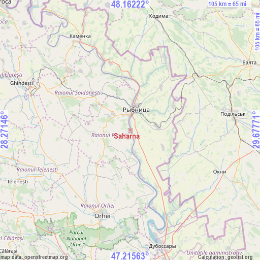
Saharna GPS coordinates[2]
47° 41' 27.852" North, 28° 58' 28.488" East
| Map corner | latitude | longitude |
|---|---|---|
| Upper-left | 48.16222°, | 28.27146° |
| Center: | 47.69107°, | 28.97458° |
| Lower-right: | 47.21563°, | 29.67771° |
| Map W x H: | 105.3×105.2 km | = 65.4×65.4mi |
| max Lat: | 48.43285° ⇑27.4% North |
| Saharna: | 47.69107° |
| min Lat: | ⇓72.6% South 45.48167° |
| min Long | Saharna | max Long |
| 27.07787° | 28.97458° | 29.9617° |
| W 72.6%⇐ | ⇒27.4% E |
Elevation
Elevation of Saharna is 48 m = 157 ft, and this is 44.8 m = 147 ft below average elevation for this country.
| Max E: |
241 m = 791 ft | 71.2% |
| Avg. | 92.8 m = 304 ft | |
| Saharna | 48 m = 157 ft | |
Min E: |
11 m = 36 ft | 28.8% |
See also: Moldova elevation on elevation.city.
Geographical zone
Saharna is located in North temperate zone (between Tropic of Cancer and the Arctic Circle). Distance of this North polar circle is 2098.4 km =1303.9 mi to North.| Distance of | km | miles | from Saharna |
|---|---|---|---|
| North Pole | 4704.3 | 2923.1 | to North |
| Arctic Circle | 2098.4 | 1303.9 | to North |
| Tropic Cancer | 2696.8 | 1675.7 | to South |
| Equator | 5302.7 | 3294.9 | to South |


Nearby cities:
15 places around Saharna: (largest is in red/bold)
• Camenca
43.2 km =26.8 mi,  331°
331°
• Cocieri
44.6 km =27.7 mi,  166°
166°
• Criuleni
54.9 km =34.1 mi, 165°
• Dubăsari
49.5 km =30.8 mi,  163°
163°
• Floreşti
55.6 km =34.5 mi,  293°
293°
• Ghindești
48.2 km =30 mi, 292°
• Mîndreşti
56.2 km =34.9 mi,  248°
248°
• Mărculeşti
58.3 km =36.2 mi, 289°
• Ocniţa
55.2 km =34.3 mi, 332°
• Orhei
35.9 km =22.3 mi,  198°
198°
• Rezina
6.5 km =4 mi,  354°
354°
• Rîbniţa
9 km =5.6 mi,  17°
17°
• Teleneşti
50.3 km =31.3 mi, 245°
• Ustia
49.7 km =30.9 mi, 166°
• Şoldăneşti
19.2 km =11.9 mi,  316°
316°
Sources, notices
• [Note1] Compared only with cities in Moldova existing in our database
• [Src1] Map data: © OpenStreetMap contributors (CC-BY-SA)
• [Src2] Other city data from geonames.org with taken over terms of usage.
• [Src3] Geographical zone / Annual Mean Temperature by Robert A. Rohde @ Wikipedia
