Rezina geodata
Rezina is a seat of a first-order administrative division; located in Moldova in Europe/Chisinau (GMT+3) time zone. With population of 9,806 people, there are 37 cities with bigger population in this country. Compared to other cities in Moldova, 74% of cities are located further ↓South; 69.9% of cities are located further ←West and 83.6% of cities have lower elevation than Rezina. Note1


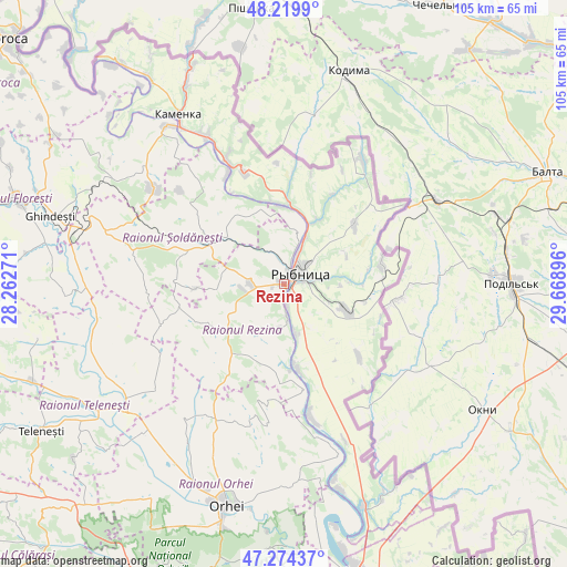
Rezina GPS coordinates[2]
47° 44' 57.408" North, 28° 57' 56.988" East
| Map corner | latitude | longitude |
|---|---|---|
| Upper-left | 48.2199°, | 28.26271° |
| Center: | 47.74928°, | 28.96583° |
| Lower-right: | 47.27437°, | 29.66896° |
| Map W x H: | 105.1×105.1 km | = 65.3×65.3mi |
| max Lat: | 48.43285° ⇑26% North |
| Rezina: | 47.74928° |
| min Lat: | ⇓74% South 45.48167° |
| min Long | Rezina | max Long |
| 27.07787° | 28.96583° | 29.9617° |
| W 69.9%⇐ | ⇒30.1% E |
Elevation
Elevation of Rezina is 138 m = 453 ft, and this is 45.2 m = 148 ft above average elevation for this country.
| Max E: |
241 m = 791 ft | 16.4% |
| Rezina | 138 m 453 ft | |
| Avg. | 92.8 m = 304 ft | |
Min E: |
11 m = 36 ft | 83.6% |
See also: Moldova elevation on elevation.city.
Geographical zone
Rezina is located in North temperate zone (between Tropic of Cancer and the Arctic Circle). Distance of this North polar circle is 2092 km =1299.9 mi to North.| Distance of | km | miles | from Rezina |
|---|---|---|---|
| North Pole | 4697.8 | 2919.1 | to North |
| Arctic Circle | 2092 | 1299.9 | to North |
| Tropic Cancer | 2703.3 | 1679.8 | to South |
| Equator | 5309.2 | 3299 | to South |


Nearby cities:
15 places around Rezina: (largest is in red/bold)
• Camenca
37.2 km =23.1 mi,  327°
327°
• Cocieri
51.1 km =31.8 mi,  167°
167°
• Criuleni
61.4 km =38.2 mi, 166°
• Dubăsari
55.9 km =34.7 mi,  164°
164°
• Floreşti
52.7 km =32.7 mi,  287°
287°
• Ghindești
45.5 km =28.3 mi,  284°
284°
• Mîndreşti
58.3 km =36.2 mi,  242°
242°
• Mărculeşti
55.7 km =34.6 mi, 283°
• Ocniţa
49.2 km =30.6 mi, 330°
• Orhei
41.9 km =26 mi,  194°
194°
• Rîbniţa
3.9 km =2.4 mi,  57°
57°
• Saharna
6.5 km =4 mi, 174°
• Teleneşti
52.8 km =32.8 mi, 238°
• Ustia
56.2 km =34.9 mi, 167°
• Şoldăneşti
14.6 km =9.1 mi,  300°
300°
Sources, notices
• [Note1] Compared only with cities in Moldova existing in our database
• [Src1] Map data: © OpenStreetMap contributors (CC-BY-SA)
• [Src2] Other city data from geonames.org with taken over terms of usage.
• [Src3] Geographical zone / Annual Mean Temperature by Robert A. Rohde @ Wikipedia
