Dancu geodata
Dancu (Hînceşti) is a populated place; located in Moldova in Europe/Chisinau (GMT+3) time zone. With population of 10,000 people, there are 35 cities with bigger population in this country. Compared to other cities in Moldova, 72.6% of cities are located further ↑North; 74% of cities are located further →East and 93.2% of cities have higher elevation than Dancu. Note1


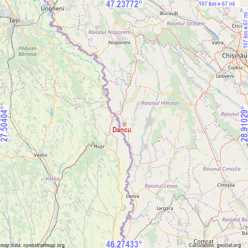
Dancu GPS coordinates[2]
46° 45' 29.448" North, 28° 12' 25.776" East
| Map corner | latitude | longitude |
|---|---|---|
| Upper-left | 47.23772°, | 27.50404° |
| Center: | 46.75818°, | 28.20716° |
| Lower-right: | 46.27433°, | 28.91029° |
| Map W x H: | 107.1×107.1 km | = 66.5×66.5mi |
| max Lat: | 48.43285° ⇑72.6% North |
| Dancu: | 46.75818° |
| min Lat: | ⇓27.4% South 45.48167° |
| min Long | Dancu | max Long |
| 27.07787° | 28.20716° | 29.9617° |
| W 26%⇐ | ⇒74% E |
Elevation
Elevation of Dancu is 24 m = 79 ft, and this is 68.8 m = 226 ft below average elevation for this country.
| Max E: |
241 m = 791 ft | 93.2% |
| Avg. | 92.8 m = 304 ft | |
| Dancu | 24 m = 79 ft | |
Min E: |
11 m = 36 ft | 6.8% |
See also: Moldova elevation on elevation.city.
Geographical zone
Dancu is located in North temperate zone (between Tropic of Cancer and the Arctic Circle). Distance of this North polar circle is 2202.2 km =1368.4 mi to North.| Distance of | km | miles | from Dancu |
|---|---|---|---|
| North Pole | 4808 | 2987.6 | to North |
| Arctic Circle | 2202.2 | 1368.4 | to North |
| Tropic Cancer | 2593.1 | 1611.3 | to South |
| Equator | 5199 | 3230.5 | to South |


Nearby cities:
15 places around Dancu: (largest is in red/bold)
• Bucovăţ
51.7 km =32.1 mi,  21°
21°
• Bugeac
55.8 km =34.7 mi,  141°
141°
• Cantemir
53.5 km =33.2 mi,  180°
180°
• Chisinau
56.6 km =35.2 mi,  60°
60°
• Cimişlia
49.7 km =30.9 mi,  121°
121°
• Călăraşi
55.9 km =34.7 mi,  8°
8°
• Hînceşti
30.3 km =18.8 mi,  74°
74°
• Ialoveni
48.3 km =30 mi, 64°
• Iargara
40.6 km =25.2 mi,  155°
155°
• Leova
30.9 km =19.2 mi,  173°
173°
• Nisporeni
36.1 km =22.4 mi,  355°
355°
• Strășeni
52.4 km =32.6 mi,  35°
35°
• Ungheni
59 km =36.7 mi,  328°
328°
• Vatra
53.4 km =33.2 mi,  48°
48°
• Vişniovca
50.8 km =31.6 mi, 158°
Sources, notices
• [Note1] Compared only with cities in Moldova existing in our database
• [Src1] Map data: © OpenStreetMap contributors (CC-BY-SA)
• [Src2] Other city data from geonames.org with taken over terms of usage.
• [Src3] Geographical zone / Annual Mean Temperature by Robert A. Rohde @ Wikipedia
