Sîngerei geodata
Sîngerei is a seat of a first-order administrative division; located in Moldova in Europe/Chisinau (GMT+3) time zone. With population of 14,600 people, there are 21 cities with bigger population in this country. Compared to other cities in Moldova, 69.9% of cities are located further ↓South; 80.8% of cities are located further →East and 50.7% of cities have higher elevation than Sîngerei. Note1


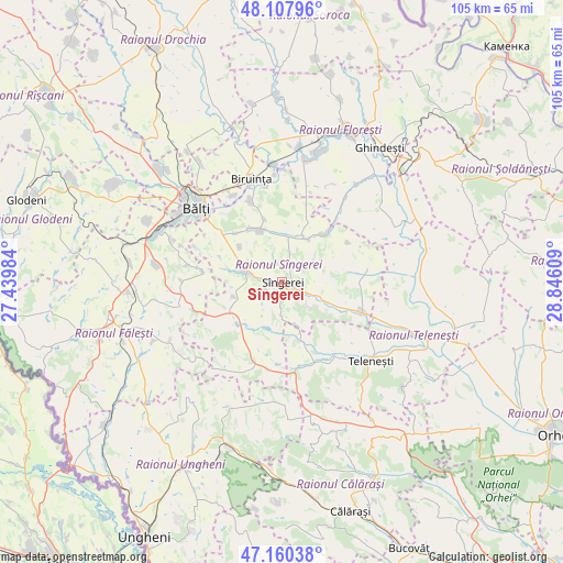
Sîngerei GPS coordinates[2]
47° 38' 10.752" North, 28° 8' 34.656" East
| Map corner | latitude | longitude |
|---|---|---|
| Upper-left | 48.10796°, | 27.43984° |
| Center: | 47.63632°, | 28.14296° |
| Lower-right: | 47.16038°, | 28.84609° |
| Map W x H: | 105.4×105.4 km | = 65.5×65.5mi |
| max Lat: | 48.43285° ⇑30.1% North |
| Sîngerei: | 47.63632° |
| min Lat: | ⇓69.9% South 45.48167° |
| min Long | Sîngerei | max Long |
| 27.07787° | 28.14296° | 29.9617° |
| W 19.2%⇐ | ⇒80.8% E |
Elevation
Elevation of Sîngerei is 90 m = 295 ft, and this is 2.8 m = 9 ft below average elevation for this country.
| Max E: |
241 m = 791 ft | 50.7% |
| Avg. | 92.8 m = 304 ft | |
| Sîngerei | 90 m = 295 ft | |
Min E: |
11 m = 36 ft | 49.3% |
See also: Moldova elevation on elevation.city.
Geographical zone
Sîngerei is located in North temperate zone (between Tropic of Cancer and the Arctic Circle). Distance of this North polar circle is 2104.5 km =1307.7 mi to North.| Distance of | km | miles | from Sîngerei |
|---|---|---|---|
| North Pole | 4710.4 | 2926.9 | to North |
| Arctic Circle | 2104.5 | 1307.7 | to North |
| Tropic Cancer | 2690.7 | 1671.9 | to South |
| Equator | 5296.7 | 3291.2 | to South |


Nearby cities:
15 places around Sîngerei: (largest is in red/bold)
• Bilicenii Vechi
7.5 km =4.7 mi,  286°
286°
• Biruinţa
20.4 km =12.7 mi,  344°
344°
• Bucovăţ
54.9 km =34.1 mi,  154°
154°
• Bălţi
21.3 km =13.2 mi,  311°
311°
• Călăraşi
44.2 km =27.5 mi,  163°
163°
• Drochia
50.8 km =31.6 mi,  330°
330°
• Floreşti
30.5 km =19 mi,  21°
21°
• Fălești
32.9 km =20.4 mi,  258°
258°
• Ghindești
29.9 km =18.6 mi,  35°
35°
• Glodeni
49.2 km =30.6 mi, 288°
• Mîndreşti
17.7 km =11 mi, 145°
• Mărculeşti
26.9 km =16.7 mi, 15°
• Teleneşti
22.5 km =14 mi,  132°
132°
• Ungheni
53.9 km =33.5 mi,  208°
208°
• Şoldăneşti
52.9 km =32.9 mi,  67°
67°
Sources, notices
• [Note1] Compared only with cities in Moldova existing in our database
• [Src1] Map data: © OpenStreetMap contributors (CC-BY-SA)
• [Src2] Other city data from geonames.org with taken over terms of usage.
• [Src3] Geographical zone / Annual Mean Temperature by Robert A. Rohde @ Wikipedia
