Floreşti geodata
Floreşti is a seat of a first-order administrative division; located in Moldova in Europe/Chisinau (GMT+3) time zone. With population of 16,759 people, there are 16 cities with bigger population in this country. Compared to other cities in Moldova, 84.9% of cities are located further ↓South; 67.1% of cities are located further →East and 71.2% of cities have lower elevation than Floreşti. Note1


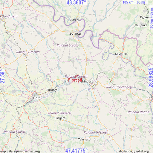
Floreşti GPS coordinates[2]
47° 53' 28.932" North, 28° 17' 35.232" East
| Map corner | latitude | longitude |
|---|---|---|
| Upper-left | 48.3607°, | 27.59° |
| Center: | 47.89137°, | 28.29312° |
| Lower-right: | 47.41775°, | 28.99625° |
| Map W x H: | 104.8×104.8 km | = 65.1×65.1mi |
| max Lat: | 48.43285° ⇑15.1% North |
| Floreşti: | 47.89137° |
| min Lat: | ⇓84.9% South 45.48167° |
| min Long | Floreşti | max Long |
| 27.07787° | 28.29312° | 29.9617° |
| W 32.9%⇐ | ⇒67.1% E |
Elevation
Elevation of Floreşti is 120 m = 394 ft, and this is 27.2 m = 89 ft above average elevation for this country.
| Max E: |
241 m = 791 ft | 28.8% |
| Floreşti | 120 m 394 ft | |
| Avg. | 92.8 m = 304 ft | |
Min E: |
11 m = 36 ft | 71.2% |
See also: Moldova elevation on elevation.city.
Geographical zone
Floreşti is located in North temperate zone (between Tropic of Cancer and the Arctic Circle). Distance of this North polar circle is 2076.2 km =1290.1 mi to North.| Distance of | km | miles | from Floreşti |
|---|---|---|---|
| North Pole | 4682 | 2909.3 | to North |
| Arctic Circle | 2076.2 | 1290.1 | to North |
| Tropic Cancer | 2719.1 | 1689.6 | to South |
| Equator | 5325 | 3308.8 | to South |


Nearby cities:
15 places around Floreşti: (largest is in red/bold)
• Bilicenii Vechi
32 km =19.9 mi,  215°
215°
• Biruinţa
18.8 km =11.7 mi,  242°
242°
• Bălţi
30.7 km =19.1 mi, 242°
• Camenca
34 km =21.1 mi,  62°
62°
• Drochia
39.2 km =24.4 mi,  294°
294°
• Ghindești
7.4 km =4.6 mi,  123°
123°
• Mîndreşti
42.9 km =26.7 mi,  181°
181°
• Mărculeşti
4.6 km =2.9 mi, 237°
• Ocniţa
37 km =23 mi,  43°
43°
• Rezina
52.7 km =32.7 mi,  107°
107°
• Rîşcani
54.7 km =34 mi,  276°
276°
• Soroca
29.5 km =18.3 mi,  358°
358°
• Sîngerei
30.5 km =19 mi,  201°
201°
• Teleneşti
43.7 km =27.2 mi,  172°
172°
• Şoldăneşti
38.5 km =23.9 mi,  102°
102°
Sources, notices
• [Note1] Compared only with cities in Moldova existing in our database
• [Src1] Map data: © OpenStreetMap contributors (CC-BY-SA)
• [Src2] Other city data from geonames.org with taken over terms of usage.
• [Src3] Geographical zone / Annual Mean Temperature by Robert A. Rohde @ Wikipedia
