Camenca geodata
Camenca (Transnistria) is a populated place; located in Moldova in Europe/Chisinau (GMT+3) time zone. With population of 11,072 people, there are 31 cities with bigger population in this country. Compared to other cities in Moldova, 87.7% of cities are located further ↓South; 52.1% of cities are located further ←West and 79.5% of cities have higher elevation than Camenca. Note1


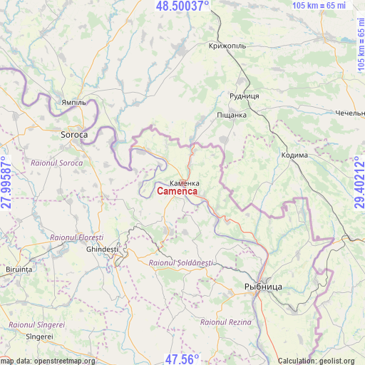
Camenca GPS coordinates[2]
48° 1' 56.388" North, 28° 41' 56.364" East
| Map corner | latitude | longitude |
|---|---|---|
| Upper-left | 48.50037°, | 27.99587° |
| Center: | 48.03233°, | 28.69899° |
| Lower-right: | 47.56°, | 29.40212° |
| Map W x H: | 104.6×104.6 km | = 65×65mi |
| max Lat: | 48.43285° ⇑12.3% North |
| Camenca: | 48.03233° |
| min Lat: | ⇓87.7% South 45.48167° |
| min Long | Camenca | max Long |
| 27.07787° | 28.69899° | 29.9617° |
| W 52.1%⇐ | ⇒47.9% E |
Elevation
Elevation of Camenca is 36 m = 118 ft, and this is 56.8 m = 186 ft below average elevation for this country.
| Max E: |
241 m = 791 ft | 79.5% |
| Avg. | 92.8 m = 304 ft | |
| Camenca | 36 m = 118 ft | |
Min E: |
11 m = 36 ft | 20.5% |
See also: Moldova elevation on elevation.city.
Geographical zone
Camenca is located in North temperate zone (between Tropic of Cancer and the Arctic Circle). Distance of this North polar circle is 2060.5 km =1280.3 mi to North.| Distance of | km | miles | from Camenca |
|---|---|---|---|
| North Pole | 4666.4 | 2899.6 | to North |
| Arctic Circle | 2060.5 | 1280.3 | to North |
| Tropic Cancer | 2734.8 | 1699.3 | to South |
| Equator | 5340.7 | 3318.6 | to South |


Nearby cities:
15 places around Camenca: (largest is in red/bold)
• Bilicenii Vechi
64.2 km =39.9 mi,  229°
229°
• Biruinţa
52.8 km =32.8 mi,  242°
242°
• Bălţi
64.7 km =40.2 mi, 242°
• Drochia
65.9 km =40.9 mi,  270°
270°
• Floreşti
34 km =21.1 mi, 242°
• Ghindești
31.1 km =19.3 mi, 230°
• Mărculeşti
38.6 km =24 mi, 241°
• Ocniţa
12.1 km =7.5 mi,  337°
337°
• Rezina
37.2 km =23.1 mi,  147°
147°
• Rîbniţa
37.4 km =23.2 mi,  141°
141°
• Saharna
43.2 km =26.8 mi, 151°
• Soroca
33.7 km =20.9 mi,  294°
294°
• Sîngerei
60.5 km =37.6 mi,  223°
223°
• Teleneşti
64.1 km =39.8 mi,  202°
202°
• Şoldăneşti
25.1 km =15.6 mi,  163°
163°
Sources, notices
• [Note1] Compared only with cities in Moldova existing in our database
• [Src1] Map data: © OpenStreetMap contributors (CC-BY-SA)
• [Src2] Other city data from geonames.org with taken over terms of usage.
• [Src3] Geographical zone / Annual Mean Temperature by Robert A. Rohde @ Wikipedia
