Šavnik geodata
Šavnik (Opština Šavnik) is a seat of a first-order administrative division; located in Montenegro in Europe/Podgorica (GMT+2) time zone. With population of 633 people, there are 47 cities with bigger population in this country. Compared to other cities in Montenegro, 88.9% of cities are located further ↓South; 55.6% of cities are located further →East and 81% of cities have lower elevation than Šavnik. Note1


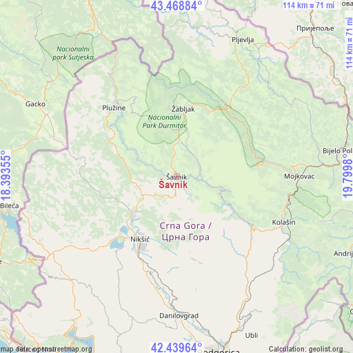
Šavnik GPS coordinates[2]
42° 57' 23.004" North, 19° 5' 48.012" East
| Map corner | latitude | longitude |
|---|---|---|
| Upper-left | 43.46884°, | 18.39355° |
| Center: | 42.95639°, | 19.09667° |
| Lower-right: | 42.43964°, | 19.7998° |
| Map W x H: | 114.4×114.4 km | = 71.1×71.1mi |
| max Lat: | 43.38472° ⇑11.1% North |
| Šavnik: | 42.95639° |
| min Lat: | ⇓88.9% South 41.92936° |
| min Long | Šavnik | max Long |
| 18.50647° | 19.09667° | 20.16652° |
| W 44.4%⇐ | ⇒55.6% E |
Elevation
Elevation of Šavnik is 843 m = 2766 ft, and this is 497 m = 1631 ft above average elevation for this country.
| Max E: |
1448 m = 4751 ft | 19% |
| Šavnik | 843 m 2766 ft | |
| Avg. | 346 m = 1135 ft | |
Min E: |
4 m = 13 ft | 81% |
See also: Montenegro elevation on elevation.city.
Geographical zone
Šavnik is located in North temperate zone (between Tropic of Cancer and the Arctic Circle). Distance of this Northern Tropic circle is 2170.4 km =1348.6 mi to South.| Distance of | km | miles | from Šavnik |
|---|---|---|---|
| North Pole | 5230.8 | 3250.3 | to North |
| Arctic Circle | 2624.9 | 1631 | to North |
| Tropic Cancer | 2170.4 | 1348.6 | to South |
| Equator | 4776.3 | 2967.9 | to South |


Nearby cities:
15 places around Šavnik: (largest is in red/bold)
• Barice
34.8 km =21.6 mi,  65°
65°
• Danilovgrad
44.9 km =27.9 mi,  174°
174°
• Dučice
26.9 km =16.7 mi,  175°
175°
• Kolašin
37.3 km =23.2 mi,  113°
113°
• Kuta
24 km =14.9 mi, 175°
• Miločani
21.1 km =13.1 mi,  227°
227°
• Mojkovac
39.6 km =24.6 mi,  89°
89°
• Nikšić
23.9 km =14.9 mi,  211°
211°
• Pljevlja
49.3 km =30.6 mi,  25°
25°
• Plužine
30.2 km =18.8 mi,  316°
316°
• Spuž
49.7 km =30.9 mi, 170°
• Zagrad
23 km =14.3 mi, 181°
• Ćurilac
46.9 km =29.1 mi, 177°
• Šula
47.7 km =29.6 mi,  357°
357°
• Žabljak
22.1 km =13.7 mi,  5°
5°
Sources, notices
• [Note1] Compared only with cities in Montenegro existing in our database
• [Src1] Map data: © OpenStreetMap contributors (CC-BY-SA)
• [Src2] Other city data from geonames.org with taken over terms of usage.
• [Src3] Geographical zone / Annual Mean Temperature by Robert A. Rohde @ Wikipedia
