Ifanadiana geodata
Ifanadiana (Vatovavy Fitovinany) is a populated place; located in Madagascar in Indian/Antananarivo (GMT+3) time zone. With population of 17,543 people, there are 71 cities with bigger population in this country. Compared to other cities in Madagascar, 69.9% of cities are located further ↑North; 50.4% of cities are located further →East and 58.5% of cities have lower elevation than Ifanadiana. Note1
Administrative division(s):
- Level 1: Vatovavy Fitovinany
- Level 2: Ifanadiana
- Level 3: Ifanadiana
- Level 4: Ifanadiana


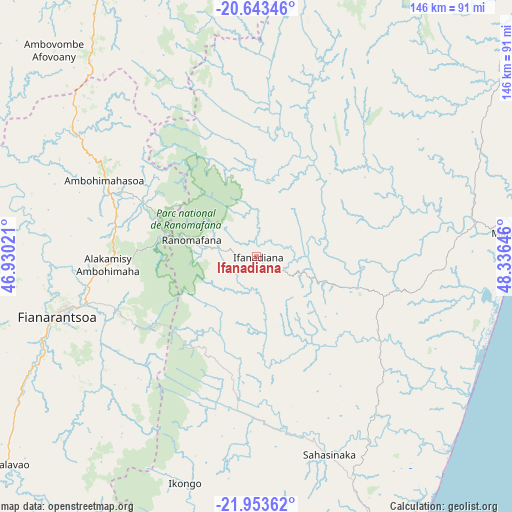
Ifanadiana GPS coordinates[2]
21° 18' 0" South, 47° 37' 59.988" East
| Map corner | latitude | longitude |
|---|---|---|
| Upper-left | -20.64346°, | 46.93021° |
| Center: | -21.3°, | 47.63333° |
| Lower-right: | -21.95362°, | 48.33646° |
| Map W x H: | 145.7×145.7 km | = 90.5×90.5mi |
| max Lat: | -12.31732° ⇑69.9% North |
| Ifanadiana: | -21.3° |
| min Lat: | ⇓30.1% South -25.3° |
| min Long | Ifanadiana | max Long |
| 43.65° | 47.63333° | 50.27876° |
| W 49.6%⇐ | ⇒50.4% E |
Elevation
Elevation of Ifanadiana is 433 m = 1421 ft, and this is 124.4 m = 408 ft below average elevation for this country.
| Max E: |
1763 m = 5784 ft | 41.5% |
| Avg. | 557.4 m = 1829 ft | |
| Ifanadiana | 433 m = 1421 ft | |
Min E: |
1 m = 3 ft | 58.5% |
See also: Madagascar elevation on elevation.city.
Geographical zone
Ifanadiana is located in South Torrid zone (between Equator and Tropic of Capricorn). Distance of this Southern Tropic circle is 237.6 km =147.6 mi to South.| Distance of | km | miles | from Ifanadiana |
|---|---|---|---|
| Equator | 2368.3 | 1471.6 | to North |
| Tropic Capricorn | 237.6 | 147.6 | to South |
| Antarctic Circle | 5032.8 | 3127.2 | to South |
| South Pole | 7638.7 | 4746.5 | to South |


Nearby cities:
15 places around Ifanadiana: (largest is in red/bold)
• Ambalavao
93.6 km =58.2 mi,  230°
230°
• Ambatofinandrahana
119.7 km =74.4 mi,  313°
313°
• Amboanjo
81 km =50.3 mi,  163°
163°
• Ambositra
94.7 km =58.8 mi,  334°
334°
• Fandrandava
46.4 km =28.8 mi,  238°
238°
• Fandriana
121.4 km =75.4 mi,  347°
347°
• Fianarantsoa
59.2 km =36.8 mi,  253°
253°
• Ifatsy
122.9 km =76.4 mi,  174°
174°
• Ikalamavony
110.1 km =68.4 mi,  278°
278°
• Ikongo
68.1 km =42.3 mi,  197°
197°
• Manakara
102.1 km =63.4 mi, 157°
• Mananjary
73.8 km =45.9 mi,  83°
83°
• Nosy Varika
122.8 km =76.3 mi,  49°
49°
• Sahavato
106.5 km =66.2 mi,  43°
43°
• Vohimanitra
45 km =28 mi, 171°
Sources, notices
• [Note1] Compared only with cities in Madagascar existing in our database
• [Src1] Map data: © OpenStreetMap contributors (CC-BY-SA)
• [Src2] Other city data from geonames.org with taken over terms of usage.
• [Src3] Geographical zone / Annual Mean Temperature by Robert A. Rohde @ Wikipedia
