Andovoranto geodata
Andovoranto (Atsinanana) is a populated place; located in Madagascar in Indian/Antananarivo (GMT+3) time zone. With population of 10,429 people, there are 90 cities with bigger population in this country. Compared to other cities in Madagascar, 54.5% of cities are located further ↓South; 87% of cities are located further ←West and 91.9% of cities have higher elevation than Andovoranto. Note1
Administrative division(s):
- Level 1: Atsinanana
- Level 2: Brickaville
- Level 3: Andevoranto
- Level 4: Andovoranto


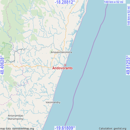
Andovoranto GPS coordinates[2]
18° 57' 15.948" South, 49° 6' 33.84" East
| Map corner | latitude | longitude |
|---|---|---|
| Upper-left | -18.28812°, | 48.40628° |
| Center: | -18.95443°, | 49.1094° |
| Lower-right: | -19.61809°, | 49.81253° |
| Map W x H: | 147.9×147.9 km | = 91.9×91.9mi |
| max Lat: | -12.31732° ⇑45.5% North |
| Andovoranto: | -18.95443° |
| min Lat: | ⇓54.5% South -25.3° |
| min Long | Andovoranto | max Long |
| 43.65° | 49.1094° | 50.27876° |
| W 87%⇐ | ⇒13% E |
Elevation
Elevation of Andovoranto is 10 m = 33 ft, and this is 547.4 m = 1796 ft below average elevation for this country.
| Max E: |
1763 m = 5784 ft | 91.9% |
| Avg. | 557.4 m = 1829 ft | |
| Andovoranto | 10 m = 33 ft | |
Min E: |
1 m = 3 ft | 8.1% |
See also: Madagascar elevation on elevation.city.
Geographical zone
Andovoranto is located in South Torrid zone (between Equator and Tropic of Capricorn). Distance of this Southern Tropic circle is 498.4 km =309.7 mi to South.| Distance of | km | miles | from Andovoranto |
|---|---|---|---|
| Equator | 2107.5 | 1309.5 | to North |
| Tropic Capricorn | 498.4 | 309.7 | to South |
| Antarctic Circle | 5293.6 | 3289.3 | to South |
| South Pole | 7899.5 | 4908.5 | to South |


Nearby cities:
15 places around Andovoranto: (largest is in red/bold)
• Alarobia
144.7 km =89.9 mi,  269°
269°
• Ambatolaona
127.2 km =79 mi, 271°
• Ambatondrazaka
144.5 km =89.8 mi,  329°
329°
• Ambohitrandriamanitra
140.1 km =87.1 mi,  264°
264°
• Ambohitseheno
139.1 km =86.4 mi,  277°
277°
• Ampasimanolotra
16 km =9.9 mi,  343°
343°
• Ankazondandy
142.4 km =88.5 mi, 281°
• Mahanoro
110 km =68.4 mi,  197°
197°
• Manjakandriana
137.8 km =85.6 mi, 271°
• Mantasoa
134.3 km =83.5 mi, 267°
• Merikanjaka
133.9 km =83.2 mi, 261°
• Miadanandriana
139.7 km =86.8 mi, 266°
• Moramanga
92.5 km =57.5 mi, 270°
• Sambaina
139.6 km =86.7 mi, 272°
• Toamasina
94.7 km =58.8 mi,  19°
19°
Sources, notices
• [Note1] Compared only with cities in Madagascar existing in our database
• [Src1] Map data: © OpenStreetMap contributors (CC-BY-SA)
• [Src2] Other city data from geonames.org with taken over terms of usage.
• [Src3] Geographical zone / Annual Mean Temperature by Robert A. Rohde @ Wikipedia
