Mahanoro geodata
Mahanoro (Atsinanana) is a populated place; located in Madagascar in Indian/Antananarivo (GMT+3) time zone. With population of 39,879 people, there are 15 cities with bigger population in this country. Compared to other cities in Madagascar, 61.8% of cities are located further ↑North; 78.9% of cities are located further ←West and 98.4% of cities have higher elevation than Mahanoro. Note1
Administrative division(s):
- Level 1: Atsinanana
- Level 2: Mahanoro
- Level 3: Mahanoro
- Level 4: Vohitromby


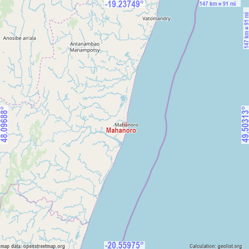
Mahanoro GPS coordinates[2]
19° 54' 0" South, 48° 48' 0" East
| Map corner | latitude | longitude |
|---|---|---|
| Upper-left | -19.23749°, | 48.09688° |
| Center: | -19.9°, | 48.8° |
| Lower-right: | -20.55975°, | 49.50313° |
| Map W x H: | 147×147 km | = 91.3×91.3mi |
| max Lat: | -12.31732° ⇑61.8% North |
| Mahanoro: | -19.9° |
| min Lat: | ⇓38.2% South -25.3° |
| min Long | Mahanoro | max Long |
| 43.65° | 48.8° | 50.27876° |
| W 78.9%⇐ | ⇒21.1% E |
Elevation
Elevation of Mahanoro is 3 m = 10 ft, and this is 554.4 m = 1819 ft below average elevation for this country.
| Max E: |
1763 m = 5784 ft | 98.4% |
| Avg. | 557.4 m = 1829 ft | |
| Mahanoro | 3 m = 10 ft | |
Min E: |
1 m = 3 ft | 1.6% |
See also: Madagascar elevation on elevation.city.
Geographical zone
Mahanoro is located in South Torrid zone (between Equator and Tropic of Capricorn). Distance of this Southern Tropic circle is 393.2 km =244.3 mi to South.| Distance of | km | miles | from Mahanoro |
|---|---|---|---|
| Equator | 2212.7 | 1374.9 | to North |
| Tropic Capricorn | 393.2 | 244.3 | to South |
| Antarctic Circle | 5188.5 | 3224 | to South |
| South Pole | 7794.4 | 4843.2 | to South |


Nearby cities:
15 places around Mahanoro: (largest is in red/bold)
• Alarobia
152.6 km =94.8 mi,  312°
312°
• Ambatolaona
143 km =88.9 mi,  318°
318°
• Ambohitrandriamanitra
140 km =87 mi, 310°
• Ampasimanolotra
123.7 km =76.9 mi,  13°
13°
• Andovoranto
110 km =68.4 mi,  17°
17°
• Andramasina
149.5 km =92.9 mi,  301°
301°
• Fandriana
152.5 km =94.8 mi,  255°
255°
• Manjakandriana
151.5 km =94.1 mi, 316°
• Mantasoa
141.1 km =87.7 mi, 314°
• Marolambo
73.3 km =45.5 mi, 256°
• Merikanjaka
131.1 km =81.5 mi, 310°
• Miadanandriana
143.7 km =89.3 mi, 312°
• Moramanga
121.4 km =75.4 mi,  330°
330°
• Nosy Varika
80.9 km =50.3 mi,  200°
200°
• Sahavato
91.8 km =57 mi,  212°
212°
Sources, notices
• [Note1] Compared only with cities in Madagascar existing in our database
• [Src1] Map data: © OpenStreetMap contributors (CC-BY-SA)
• [Src2] Other city data from geonames.org with taken over terms of usage.
• [Src3] Geographical zone / Annual Mean Temperature by Robert A. Rohde @ Wikipedia
