Ansongo geodata
Ansongo (Gao) is a seat of a second-order administrative division; located in Mali in Africa/Bamako (GMT+0) time zone. With population of 3,000 people, there are 38 cities with bigger population in this country. Compared to other cities in Mali, 75.4% of cities are located further ↓South; 90.2% of cities are located further ←West and 85.2% of cities have higher elevation than Ansongo. Note1


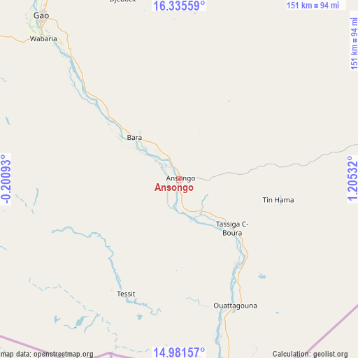
Ansongo GPS coordinates[2]
15° 39' 34.92" North, 0° 30' 7.92" East
| Map corner | latitude | longitude |
|---|---|---|
| Upper-left | 16.33559°, | -0.20093° |
| Center: | 15.6597°, | 0.5022° |
| Lower-right: | 14.98157°, | 1.20532° |
| Map W x H: | 150.6×150.6 km | = 93.6×93.6mi |
| max Lat: | 22.67443° ⇑24.6% North |
| Ansongo: | 15.6597° |
| min Lat: | ⇓75.4% South 10.55° |
| min Long | Ansongo | max Long |
| -11.44448° | 0.5022° | 3.14111° |
| W 90.2%⇐ | ⇒9.8% E |
Elevation
Elevation of Ansongo is 260 m = 853 ft, and this is 48 m = 157 ft below average elevation for this country.
| Max E: |
540 m = 1772 ft | 85.2% |
| Avg. | 308 m = 1010 ft | |
| Ansongo | 260 m = 853 ft | |
Min E: |
39 m = 128 ft | 14.8% |
See also: Mali elevation on elevation.city.
Geographical zone
Ansongo is located in North Torrid zone (between Equator and Tropic of Cancer). Distance of this Northern Tropic circle is 864.7 km =537.3 mi to North.| Distance of | km | miles | from Ansongo |
|---|---|---|---|
| North Pole | 8265.9 | 5136.2 | to North |
| Arctic Circle | 5660 | 3517 | to North |
| Tropic Cancer | 864.7 | 537.3 | to North |
| Equator | 1741.2 | 1081.9 | to South |


Nearby cities:
12 places around Ansongo: (largest is in red/bold)
• Abeïbara
406.5 km =252.6 mi,  19°
19°
• Bourem
170.3 km =105.8 mi,  327°
327°
• Diré
422.5 km =262.5 mi,  279°
279°
• Douentza
377.3 km =234.4 mi,  258°
258°
• Gao
89.7 km =55.7 mi,  319°
319°
• Gourma Rharous
292.1 km =181.5 mi,  297°
297°
• Inékar
284.3 km =176.7 mi,  83°
83°
• Kidal
323.9 km =201.3 mi, 17°
• Koro
423.4 km =263.1 mi,  245°
245°
• Ménaka
205.3 km =127.6 mi, 81°
• Ti-n-Essako
375.3 km =233.2 mi,  34°
34°
• Timbuktu
394.6 km =245.2 mi,  288°
288°
Sources, notices
• [Note1] Compared only with cities in Mali existing in our database
• [Src1] Map data: © OpenStreetMap contributors (CC-BY-SA)
• [Src2] Other city data from geonames.org with taken over terms of usage.
• [Src3] Geographical zone / Annual Mean Temperature by Robert A. Rohde @ Wikipedia
