Douentza geodata
Douentza (Mopti) is a seat of a second-order administrative division; located in Mali in Africa/Bamako (GMT+0) time zone. With population of 8,054 people, there are 29 cities with bigger population in this country. Compared to other cities in Mali, 67.2% of cities are located further ↓South; 83.6% of cities are located further ←West and 55.7% of cities have lower elevation than Douentza. Note1


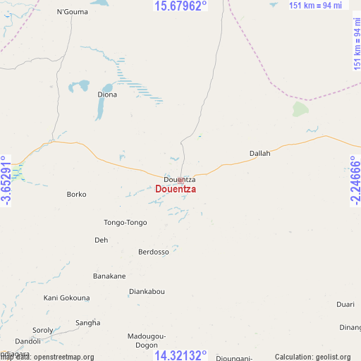
Douentza GPS coordinates[2]
15° 0' 5.58" North, 2° 56' 59.208" West
| Map corner | latitude | longitude |
|---|---|---|
| Upper-left | 15.67962°, | -3.65291° |
| Center: | 15.00155°, | -2.94978° |
| Lower-right: | 14.32132°, | -2.24666° |
| Map W x H: | 151×151 km | = 93.8×93.8mi |
| max Lat: | 22.67443° ⇑32.8% North |
| Douentza: | 15.00155° |
| min Lat: | ⇓67.2% South 10.55° |
| min Long | Douentza | max Long |
| -11.44448° | -2.94978° | 3.14111° |
| W 83.6%⇐ | ⇒16.4% E |
Elevation
Elevation of Douentza is 303 m = 994 ft, and this is 5 m = 16 ft below average elevation for this country.
| Max E: |
540 m = 1772 ft | 44.3% |
| Avg. | 308 m = 1010 ft | |
| Douentza | 303 m = 994 ft | |
Min E: |
39 m = 128 ft | 55.7% |
See also: Mali elevation on elevation.city.
Geographical zone
Douentza is located in North Torrid zone (between Equator and Tropic of Cancer). Distance of this Northern Tropic circle is 937.9 km =582.8 mi to North.| Distance of | km | miles | from Douentza |
|---|---|---|---|
| North Pole | 8339 | 5181.6 | to North |
| Arctic Circle | 5733.2 | 3562.4 | to North |
| Tropic Cancer | 937.9 | 582.8 | to North |
| Equator | 1668 | 1036.4 | to South |


Nearby cities:
15 places around Douentza: (largest is in red/bold)
• Bandiagara
101.5 km =63.1 mi,  224°
224°
• Bankass
119.5 km =74.3 mi,  210°
210°
• Diré
147.7 km =91.8 mi,  340°
340°
• Djénné
211.3 km =131.3 mi,  234°
234°
• Goundam
175 km =108.7 mi,  333°
333°
• Gourma Rharous
235.7 km =146.5 mi,  27°
27°
• Koro
105.1 km =65.3 mi,  187°
187°
• Ké-Macina
283.8 km =176.3 mi,  246°
246°
• Mopti
144.5 km =89.8 mi, 246°
• Niafunké
152.1 km =94.5 mi,  312°
312°
• San
282.2 km =175.4 mi, 228°
• Timbuktu
197.1 km =122.5 mi,  358°
358°
• Tominian
260.2 km =161.7 mi, 222°
• Ténenkou
220 km =136.7 mi, 254°
• Youwarou
146.7 km =91.2 mi,  286°
286°
Sources, notices
• [Note1] Compared only with cities in Mali existing in our database
• [Src1] Map data: © OpenStreetMap contributors (CC-BY-SA)
• [Src2] Other city data from geonames.org with taken over terms of usage.
• [Src3] Geographical zone / Annual Mean Temperature by Robert A. Rohde @ Wikipedia
