Gao geodata
Gao is a seat of a first-order administrative division; located in Mali in Africa/Bamako (GMT+0) time zone. With population of 87,000 people, there are 5 cities with bigger population in this country. Compared to other cities in Mali, 83.6% of cities are located further ↓South; 88.5% of cities are located further ←West and 88.5% of cities have higher elevation than Gao. Note1


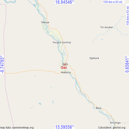
Gao GPS coordinates[2]
16° 16' 18.012" North, 0° 2' 40.992" West
| Map corner | latitude | longitude |
|---|---|---|
| Upper-left | 16.94546°, | -0.74785° |
| Center: | 16.27167°, | -0.04472° |
| Lower-right: | 15.59556°, | 0.65841° |
| Map W x H: | 150.1×150.1 km | = 93.3×93.3mi |
| max Lat: | 22.67443° ⇑16.4% North |
| Gao: | 16.27167° |
| min Lat: | ⇓83.6% South 10.55° |
| min Long | Gao | max Long |
| -11.44448° | -0.04472° | 3.14111° |
| W 88.5%⇐ | ⇒11.5% E |
Elevation
Elevation of Gao is 257 m = 843 ft, and this is 51 m = 167 ft below average elevation for this country.
| Max E: |
540 m = 1772 ft | 88.5% |
| Avg. | 308 m = 1010 ft | |
| Gao | 257 m = 843 ft | |
Min E: |
39 m = 128 ft | 11.5% |
See also: Gao elevation on elevation.city.
Geographical zone
Gao is located in North Torrid zone (between Equator and Tropic of Cancer). Distance of this Northern Tropic circle is 796.7 km =495 mi to North.| Distance of | km | miles | from Gao |
|---|---|---|---|
| North Pole | 8197.8 | 5093.9 | to North |
| Arctic Circle | 5591.9 | 3474.6 | to North |
| Tropic Cancer | 796.7 | 495 | to North |
| Equator | 1809.2 | 1124.2 | to South |


Nearby cities:
14 places around Gao: (largest is in red/bold)
• Abeïbara
369.1 km =229.3 mi,  31°
31°
• Ansongo
89.7 km =55.7 mi,  139°
139°
• Bourem
82.6 km =51.3 mi,  336°
336°
• Diré
358.3 km =222.6 mi,  269°
269°
• Douentza
341.6 km =212.3 mi,  245°
245°
• Goundam
387.2 km =240.6 mi, 272°
• Gourma Rharous
211.2 km =131.2 mi,  288°
288°
• Inékar
342.1 km =212.6 mi,  95°
95°
• Kidal
286.3 km =177.9 mi, 32°
• Koro
407.5 km =253.2 mi,  232°
232°
• Ménaka
264.3 km =164.2 mi, 98°
• Niafunké
423.2 km =263 mi,  264°
264°
• Ti-n-Essako
361.8 km =224.8 mi,  47°
47°
• Timbuktu
320.7 km =199.3 mi,  280°
280°
Sources, notices
• [Note1] Compared only with cities in Mali existing in our database
• [Src1] Map data: © OpenStreetMap contributors (CC-BY-SA)
• [Src2] Other city data from geonames.org with taken over terms of usage.
• [Src3] Geographical zone / Annual Mean Temperature by Robert A. Rohde @ Wikipedia
