Ulan Bator geodata
Ulan Bator (Ulaanbaatar) is a capital of a political entity; located in Mongolia in Asia/Ulaanbaatar (GMT+8) time zone. With population of 844,818 people, there are 0 cities with bigger population in this country. Compared to other cities in Mongolia, 55.5% of cities are located further ↓South; 76.7% of cities are located further ←West and 58.9% of cities have higher elevation than Ulan Bator. Note1


Ulan Bator GPS coordinates[2]
47° 54' 27.756" North, 106° 52' 59.664" East
| Map corner | latitude | longitude |
|---|---|---|
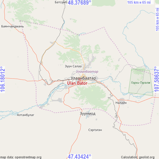
| Upper-left | 48.37689°, | 106.18012° |
| Center: | 47.90771°, | 106.88324° |
| Lower-right: | 47.43424°, | 107.58637° |
| Map W x H: | 104.8×104.8 km | = 65.1×65.1mi |
| max Lat: | 51.50725° ⇑44.5% North |
| Ulan Bator: | 47.90771° |
| min Lat: | ⇓55.5% South 42.84199° |
| min Long | Ulan Bator | max Long |
| 89.14358° | 106.88324° | 118.51014° |
| W 76.7%⇐ | ⇒23.3% E |
Elevation
Elevation of Ulan Bator is 1284 m = 4213 ft, and this is 132.5 m = 435 ft below average elevation for this country.
| Max E: |
2800 m = 9186 ft | 58.9% |
| Avg. | 1416.5 m = 4647 ft | |
| Ulan Bator | 1284 m = 4213 ft | |
Min E: |
619 m = 2031 ft | 41.1% |
See also: Ulan Bator elevation on elevation.city.
Geographical zone
Ulan Bator is located in North temperate zone (between Tropic of Cancer and the Arctic Circle). Distance of this North polar circle is 2074.3 km =1288.9 mi to North.| Distance of | km | miles | from Ulan Bator |
|---|---|---|---|
| North Pole | 4680.2 | 2908.1 | to North |
| Arctic Circle | 2074.3 | 1288.9 | to North |
| Tropic Cancer | 2720.9 | 1690.7 | to South |
| Equator | 5326.8 | 3309.9 | to South |


Nearby cities:
15 places around Ulan Bator: (largest is in red/bold)
• Altanbulag
42.8 km =26.6 mi,  237°
237°
• Argalant
73.7 km =45.8 mi,  272°
272°
• Arhust
75.7 km =47 mi,  99°
99°
• Bayandelger
93.8 km =58.3 mi, 102°
• Bornuur
77.1 km =47.9 mi,  323°
323°
• Dund-Urt
73 km =45.4 mi,  281°
281°
• Dzuunmod
22.9 km =14.2 mi,  166°
166°
• Dzüünkharaa
81.4 km =50.6 mi,  352°
352°
• Höshigiyn-Ar
39.4 km =24.5 mi, 171°
• Ihsüüj
56.4 km =35 mi,  308°
308°
• Jargalant
101.5 km =63.1 mi, 312°
• Maanĭt
87.9 km =54.6 mi,  146°
146°
• Mandal
52.5 km =32.6 mi, 348°
• Ulaanhad
99.2 km =61.6 mi, 272°
• Зуунмод
22.9 km =14.2 mi, 166°
In other languages:
- In Spanish: Ulán Bator
- In France: Oulan-Bator
- In German: Ulaanbaatar
- In Russian: Улан-Батор
- In Chinese: 乌兰巴托
Sources, notices
• [Note1] Compared only with cities in Mongolia existing in our database
• [Src1] Map data: © OpenStreetMap contributors (CC-BY-SA)
• [Src2] Other city data from geonames.org with taken over terms of usage.
• [Src3] Geographical zone / Annual Mean Temperature by Robert A. Rohde @ Wikipedia
