Maanĭt geodata
Maanĭt (Central Aimak) is a seat of a second-order administrative division; located in Mongolia in Asia/Ulaanbaatar (GMT+8) time zone. In our database, there are 33 cities with bigger population. Compared to other cities in Mongolia, 57.4% of cities are located further ↑North; 79.4% of cities are located further ←West and 53.1% of cities have lower elevation than Maanĭt. Note1


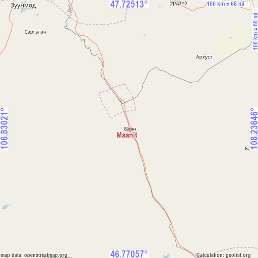
Maanĭt GPS coordinates[2]
47° 15' 0" North, 107° 31' 59.988" East
| Map corner | latitude | longitude |
|---|---|---|
| Upper-left | 47.72513°, | 106.83021° |
| Center: | 47.25°, | 107.53333° |
| Lower-right: | 46.77057°, | 108.23646° |
| Map W x H: | 106.1×106.1 km | = 65.9×65.9mi |
| max Lat: | 51.50725° ⇑57.4% North |
| Maanĭt: | 47.25° |
| min Lat: | ⇓42.6% South 42.84199° |
| min Long | Maanĭt | max Long |
| 89.14358° | 107.53333° | 118.51014° |
| W 79.4%⇐ | ⇒20.6% E |
Elevation
Elevation of Maanĭt is 1413 m = 4636 ft, and this is 3.5 m = 11 ft below average elevation for this country.
| Max E: |
2800 m = 9186 ft | 46.9% |
| Avg. | 1416.5 m = 4647 ft | |
| Maanĭt | 1413 m = 4636 ft | |
Min E: |
619 m = 2031 ft | 53.1% |
See also: Mongolia elevation on elevation.city.
Geographical zone
Maanĭt is located in North temperate zone (between Tropic of Cancer and the Arctic Circle). Distance of this North polar circle is 2147.5 km =1334.4 mi to North.| Distance of | km | miles | from Maanĭt |
|---|---|---|---|
| North Pole | 4753.4 | 2953.6 | to North |
| Arctic Circle | 2147.5 | 1334.4 | to North |
| Tropic Cancer | 2647.8 | 1645.3 | to South |
| Equator | 5253.7 | 3264.5 | to South |


Nearby cities:
15 places around Maanĭt: (largest is in red/bold)
• Altanbulag
98.8 km =61.4 mi,  300°
300°
• Arhust
66 km =41 mi,  23°
23°
• Avraga
125.3 km =77.9 mi,  93°
93°
• Bayanbaraat
106.1 km =65.9 mi,  246°
246°
• Bayandelger
68.5 km =42.6 mi,  39°
39°
• Bayantal
96.3 km =59.8 mi,  142°
142°
• Bayasgalant
55.4 km =34.4 mi,  98°
98°
• Choyr
117.2 km =72.8 mi,  147°
147°
• Dzogsool
57.9 km =36 mi,  210°
210°
• Dzuunmod
67 km =41.6 mi,  319°
319°
• Haraat
93.1 km =57.8 mi,  174°
174°
• Höshigiyn-Ar
54.8 km =34.1 mi,  308°
308°
• Modot
126.8 km =78.8 mi,  63°
63°
• Ulan Bator
87.9 km =54.6 mi,  326°
326°
• Зуунмод
67 km =41.6 mi, 319°
Sources, notices
• [Note1] Compared only with cities in Mongolia existing in our database
• [Src1] Map data: © OpenStreetMap contributors (CC-BY-SA)
• [Src2] Other city data from geonames.org with taken over terms of usage.
• [Src3] Geographical zone / Annual Mean Temperature by Robert A. Rohde @ Wikipedia
