Ihsüüj geodata
Ihsüüj (Central Aimak) is a seat of a second-order administrative division; located in Mongolia in Asia/Ulaanbaatar (GMT+8) time zone. In our database, there are 33 cities with bigger population. Compared to other cities in Mongolia, 62% of cities are located further ↓South; 73.3% of cities are located further ←West and 61% of cities have higher elevation than Ihsüüj. Note1


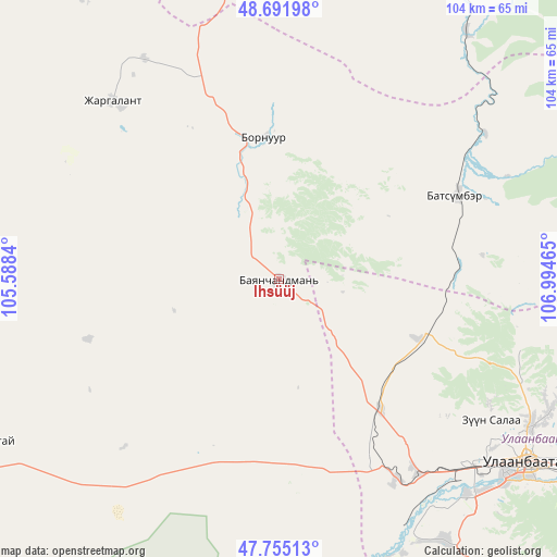
Ihsüüj GPS coordinates[2]
48° 13' 32.52" North, 106° 17' 29.472" East
| Map corner | latitude | longitude |
|---|---|---|
| Upper-left | 48.69198°, | 105.5884° |
| Center: | 48.2257°, | 106.29152° |
| Lower-right: | 47.75513°, | 106.99465° |
| Map W x H: | 104.2×104.2 km | = 64.7×64.7mi |
| max Lat: | 51.50725° ⇑38% North |
| Ihsüüj: | 48.2257° |
| min Lat: | ⇓62% South 42.84199° |
| min Long | Ihsüüj | max Long |
| 89.14358° | 106.29152° | 118.51014° |
| W 73.3%⇐ | ⇒26.7% E |
Elevation
Elevation of Ihsüüj is 1269 m = 4163 ft, and this is 147.5 m = 484 ft below average elevation for this country.
| Max E: |
2800 m = 9186 ft | 61% |
| Avg. | 1416.5 m = 4647 ft | |
| Ihsüüj | 1269 m = 4163 ft | |
Min E: |
619 m = 2031 ft | 39% |
See also: Mongolia elevation on elevation.city.
Geographical zone
Ihsüüj is located in North temperate zone (between Tropic of Cancer and the Arctic Circle). Distance of this North polar circle is 2039 km =1267 mi to North.| Distance of | km | miles | from Ihsüüj |
|---|---|---|---|
| North Pole | 4644.9 | 2886.2 | to North |
| Arctic Circle | 2039 | 1267 | to North |
| Tropic Cancer | 2756.3 | 1712.7 | to South |
| Equator | 5362.2 | 3331.9 | to South |


Nearby cities:
15 places around Ihsüüj: (largest is in red/bold)
• Altanbulag
59 km =36.7 mi,  172°
172°
• Ar-Asgat
65.3 km =40.6 mi,  273°
273°
• Argalant
43.1 km =26.8 mi,  222°
222°
• Bornuur
26.9 km =16.7 mi,  356°
356°
• Dund-Urt
34.5 km =21.4 mi,  232°
232°
• Dzuunmod
75.8 km =47.1 mi,  139°
139°
• Dzüünharaa
70.7 km =43.9 mi,  9°
9°
• Dzüünkharaa
55.8 km =34.7 mi,  35°
35°
• Jargalant
45.3 km =28.1 mi,  316°
316°
• Javhlant
69.6 km =43.2 mi,  337°
337°
• Mandal
36.9 km =22.9 mi,  64°
64°
• Orgil
76.3 km =47.4 mi,  289°
289°
• Ulaanhad
62.8 km =39 mi,  240°
240°
• Ulan Bator
56.4 km =35 mi,  128°
128°
• Зуунмод
75.8 km =47.1 mi, 139°
Sources, notices
• [Note1] Compared only with cities in Mongolia existing in our database
• [Src1] Map data: © OpenStreetMap contributors (CC-BY-SA)
• [Src2] Other city data from geonames.org with taken over terms of usage.
• [Src3] Geographical zone / Annual Mean Temperature by Robert A. Rohde @ Wikipedia
